File:Kesik Beli-Karawanenroute.jpg

Size of this preview: 436 × 600 pixels. Other resolutions: 174 × 240 pixels | 349 × 480 pixels | 764 × 1,051 pixels.
Original file (764 × 1,051 pixels, file size: 282 KB, MIME type: image/jpeg)
Captions
Captions
Add a one-line explanation of what this file represents
Summary edit
| Description |
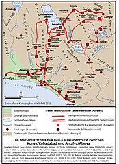
Deutsch: Die Kartenskizze zeigt den Verlauf der Hauptroute des seldschukischen Karawanenweges mit der Lage der entsprechenden Karawansereien zwischen Konya im zentralanatolischen Hochland bzw. Kubadabad am Beşehir Gölü und den Küstenorten Antalya, Alanya und Side zusammen mit einigen Alternativrouten. |
| Date | 08.12.2021 |
| Source | Own work |
| Author | Volker Höhfeld |
Licensing edit
I, the copyright holder of this work, hereby publish it under the following license:
This file is licensed under the Creative Commons Attribution-Share Alike 4.0 International license.
- You are free:
- to share – to copy, distribute and transmit the work
- to remix – to adapt the work
- Under the following conditions:
- attribution – You must give appropriate credit, provide a link to the license, and indicate if changes were made. You may do so in any reasonable manner, but not in any way that suggests the licensor endorses you or your use.
- share alike – If you remix, transform, or build upon the material, you must distribute your contributions under the same or compatible license as the original.
File history
Click on a date/time to view the file as it appeared at that time.
| Date/Time | Thumbnail | Dimensions | User | Comment | |
|---|---|---|---|---|---|
| current | 15:45, 8 December 2021 | | 764 × 1,051 (282 KB) | Volker Höhfeld (talk | contribs) | Uploaded own work with UploadWizard |
You cannot overwrite this file.
File usage on Commons
There are no pages that use this file.
File usage on other wikis
The following other wikis use this file:
- Usage on de.wikipedia.org