File:Kianida Island or Cianeis Insula.png

Size of this preview: 800 × 536 pixels. Other resolutions: 320 × 214 pixels | 640 × 429 pixels | 951 × 637 pixels.
Original file (951 × 637 pixels, file size: 1.74 MB, MIME type: image/png)
Captions
Captions
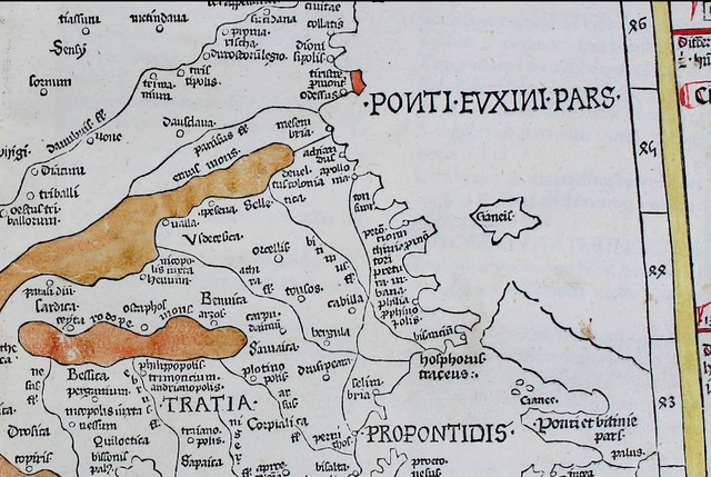
The phantom island of Kianida or Cianeis in Black Sea
Summary edit
| Description |
English: A large island off the en:Black Sea coast of en:Thrace in the present Bulgaria-Turkey border area. Depicted on the 1467 map Nona Europae Tabula by en:Nicolaus Germanus based on en:Claudius Ptolemy's Geography.[1] |
| Date | |
| Source | https://archive.org/details/cosmographia00ptol/page/n195 |
| Author | en:Nicolaus Germanus |
Licensing edit
|
This work is in the public domain in its country of origin and other countries and areas where the copyright term is the author's life plus 70 years or fewer. This work is in the public domain in the United States because it was published (or registered with the U.S. Copyright Office) before January 1, 1929. | |
| This file has been identified as being free of known restrictions under copyright law, including all related and neighboring rights. | |
- ↑ Claudius Ptolemaeius (1482) Claudii Ptolomei Viri Alexandrini Cosmographie Octavus et Ultimus Liber Explicit Opus[1], Ulm: Leinhart Holle
File history
Click on a date/time to view the file as it appeared at that time.
| Date/Time | Thumbnail | Dimensions | User | Comment | |
|---|---|---|---|---|---|
| current | 13:02, 18 November 2019 | | 951 × 637 (1.74 MB) | Apcbg (talk | contribs) | User created page with UploadWizard |
You cannot overwrite this file.
File usage on Commons
There are no pages that use this file.
File usage on other wikis
The following other wikis use this file:
- Usage on bn.wikipedia.org
- Usage on en.wikipedia.org