File:Kis-vlachföldek.png

Size of this preview: 800 × 600 pixels. Other resolutions: 320 × 240 pixels | 640 × 480 pixels | 835 × 626 pixels.
Original file (835 × 626 pixels, file size: 567 KB, MIME type: image/png)
Captions
Captions
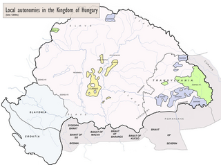
Map of Hungary in the late 13th century, background from [https://en.wikipedia.org/wiki/File:Hungary_13th_cent.png] added with the Vlachs communities under Vlach Jog attested by Mihályi János : ''Magyar diplomák a XIII és XIV századbol''.

Summary edit
| Description |
Français : Carte de la Hongrie à la fin du XIIIe siècle, fond de carte de [1] mais figurant aussi les zones roumanophones sous chartes du Vlach Jog attestées par Mihályi János : Magyar diplomák a XIII és XIV századbol. |
| Date | |
| Source | Czamańska, Ilona. The Vlachs – several research problems. Balcanica Posnaniensia - Acta et studia n° 22, february 2015, 1, pp. 7–16; Ovid Sachelarie, Nicolae Stoicescu (dir.)Instituţii feudale din ţările române, Romanian Academy Press, Bucharest 1988; Alexandru Avram, Mircea Babeş, Lucian Badea, Mircea Petrescu-Dîmboviţa & Alexandru Vulpe (dir.) Istoria românilor : moştenirea timpurilor îndepărtate, vol.1, Editura Enciclopedică, Bucharest 2001, ISBN 973-45-0382-0; Xenopol, Alexandre. Une énigme historique: les Roumains au Moyen Âge, E. Leroux, Paris, 1883 & "Histoire des Roumains de la Dacie Trajane", E. Leroux, Paris, 1896 |
| Author | Derivative map by Julieta39 |
| Permission (Reusing this file) |
Own work |
![[1]](https://en.wikipedia.org/wiki/File:Hungary_13th_cent.png)
Licensing edit
I, the copyright holder of this work, hereby publish it under the following license:
This file is licensed under the Creative Commons Attribution-Share Alike 4.0 International license.
- You are free:
- to share – to copy, distribute and transmit the work
- to remix – to adapt the work
- Under the following conditions:
- attribution – You must give appropriate credit, provide a link to the license, and indicate if changes were made. You may do so in any reasonable manner, but not in any way that suggests the licensor endorses you or your use.
- share alike – If you remix, transform, or build upon the material, you must distribute your contributions under the same or compatible license as the original.
File history
Click on a date/time to view the file as it appeared at that time.
| Date/Time | Thumbnail | Dimensions | User | Comment | |
|---|---|---|---|---|---|
| current | 23:04, 17 February 2024 | | 835 × 626 (567 KB) | WajWohu (talk | contribs) | Reverted to version as of 20:41, 1 July 2022 (UTC) Please discuss that revert on discussion page, where's a consensus and view scientific sources of: File:Magyarország XII-XIII század második felében.jpg (nearby the same borders) |
| 19:57, 16 February 2024 |  | 1,758 × 1,308 (1.49 MB) | OrionNimrod (talk | contribs) | Restore original: Vlach law existed. but it did not have borders, what is the academic source of that borders of Vlach law? That is just Photoshopped by user | |
| 20:41, 1 July 2022 |  | 835 × 626 (567 KB) | Enlightenment1685 (talk | contribs) | I restored the Romanian version | |
| 00:53, 1 July 2022 |  | 1,758 × 1,308 (1.49 MB) | Enlightenment1685 (talk | contribs) | I restoren the original version | |
| 13:10, 25 June 2022 |  | 834 × 625 (455 KB) | Trecătorul răcit (talk | contribs) | Sorry but the nationalist hungarian pov which denies the existence of Vlach Jog is not "neutral". | |
| 00:19, 4 June 2022 |  | 1,757 × 1,307 (1.25 MB) | Enlightenment1685 (talk | contribs) | The original neutral version of the map. | |
| 10:31, 20 May 2022 |  | 834 × 625 (455 KB) | Trecătorul răcit (talk | contribs) | Közös jog & details according with Történelmi atlasz, Akademiai kiado, Budapest 1991, ISBN 963-351-422-3 | |
| 19:10, 13 May 2022 |  | 834 × 625 (446 KB) | Trecătorul răcit (talk | contribs) | Added Iasses & Pechenegs | |
| 18:50, 13 May 2022 |  | 834 × 625 (446 KB) | Trecătorul răcit (talk | contribs) | Better legend | |
| 18:09, 13 May 2022 |  | 834 × 625 (454 KB) | Trecătorul răcit (talk | contribs) | Map corrected to take into account the observations of Enlightenment1685 |
You cannot overwrite this file.
File usage on Commons
There are no pages that use this file.
File usage on other wikis
The following other wikis use this file:
- Usage on de.wikipedia.org
- Usage on fr.wikipedia.org
- Usage on it.wikipedia.org