File:Klesenzatal Hutlabach.JPG

Size of this preview: 800 × 533 pixels. Other resolutions: 320 × 213 pixels | 640 × 427 pixels | 1,024 × 683 pixels | 1,280 × 853 pixels | 2,560 × 1,707 pixels | 4,272 × 2,848 pixels.
Original file (4,272 × 2,848 pixels, file size: 5.13 MB, MIME type: image/jpeg)
Captions
Captions
Add a one-line explanation of what this file represents
This image has been assessed using the Quality image guidelines and is considered a Quality image.
|
| Description |
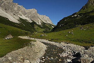
Deutsch: Der ca. 10km lange Hutlabach (ein Zufluss der Lutz) durchfliesst das Klesenzatal, das eingebettet zwischen der Roten Wand rechts und dem Gadnergschröf links ist. Berge im Bild (v.l.n.r.): Gadnerköpfe 2.271m, Misthaufen 2.436m, Hirschenspitze 2.501m. Die Alpe Klesenza wird in den Sommermonaten vom Verkehrsverbund Vorarlberg VVV mit der Linie 77a von Buchboden befahren. Ansonsten besteht ein generelles Fahrverbot. |
| Date | |
| Source | Own work |
| Author | böhringer friedrich |
| Permission (Reusing this file) |
I, the copyright holder of this work, hereby publish it under the following license: This file is licensed under the Creative Commons Attribution-Share Alike 2.5 Generic license.
|
| Other versions |
|


| Camera location | | View this and other nearby images on: OpenStreetMap |
|---|
This Photo was taken by Böhringer Friedrich.
|
Feel free to use my photos, but please mention me as the author and if you want send me a message. or (rufre@lenz-nenning.at) |
File history
Click on a date/time to view the file as it appeared at that time.
| Date/Time | Thumbnail | Dimensions | User | Comment | |
|---|---|---|---|---|---|
| current | 18:58, 20 January 2013 | | 4,272 × 2,848 (5.13 MB) | Slick-o-bot (talk | contribs) | Bot: convert to a non-interlaced jpeg image (see bugzilla:17645) |
| 08:51, 11 September 2008 |  | 4,272 × 2,848 (4.98 MB) | Böhringer (talk | contribs) | {{Information |Description= {{de| Der ca. 10km lange Hutlabach (ein Zufluss der Lutz) durchfliesst das Klesenzatal, das eingebettet zwischen der Roten Wand rechts und dem [[:de:Gadnergschröf|Gadnergschr |
You cannot overwrite this file.
File usage on Commons
The following 17 pages use this file:
- Subalpine zone
- Vorarlberg
- User:Böhringer/Archive 1
- Commons:Quality images/Subject/Places/Natural structures/archive 2008 to 2012
- Commons:Quality images candidates/Archives September 2008
- File:Alpe Klesenza Spitzegga.JPG
- File:Alpe Spitzegga 1.JPG
- File:Alpe Spitzegga 2.JPG
- File:Alpe Spitzegga 2a.jpg
- File:Alpe Spitzegga 3.JPG
- File:Alpe Spitzegga 4.JPG
- File:Alpe Spitzegga 5.JPG
- File:Bettlerspitze 2272m.JPG
- File:KlesenzaAlpeRoteWand.JPG
- File:KlesenzaAlpe Bettlerspitze.JPG
- File:Klesenza Alpe.JPG
- File:Pfarrer Josef Kary 1953.JPG
File usage on other wikis
The following other wikis use this file:
- Usage on ceb.wikipedia.org
- Usage on da.wikipedia.org
- Usage on de.wikipedia.org
- Usage on fr.wikipedia.org
- Usage on oc.wikipedia.org
- Usage on www.wikidata.org