File:Knox County, Indiana - DPLA - 84941378366069a8b175b5d1ff06b454.jpg

Size of this preview: 531 × 599 pixels. Other resolutions: 213 × 240 pixels | 425 × 480 pixels | 680 × 768 pixels | 907 × 1,024 pixels | 1,815 × 2,048 pixels | 4,480 × 5,056 pixels.
Original file (4,480 × 5,056 pixels, file size: 2.69 MB, MIME type: image/jpeg)
Captions
Captions
Add a one-line explanation of what this file represents
Summary edit
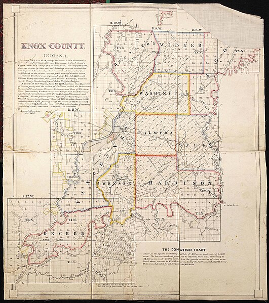
| Knox County, Indiana
( |
|||||||||||||||||||||
|---|---|---|---|---|---|---|---|---|---|---|---|---|---|---|---|---|---|---|---|---|---|
| Creator | Morrison, Samuel | ||||||||||||||||||||
| Title |
Knox County, Indiana |
||||||||||||||||||||
| Description |
This 1875 map of Knox County, Indiana shows the militia donation lands. The text inset describes military and treaty history for the area. |
||||||||||||||||||||
| Date | October 1875 | ||||||||||||||||||||
| Collection |
|
||||||||||||||||||||
| Source/Photographer |
|
||||||||||||||||||||
| Permission (Reusing this file) |
|
||||||||||||||||||||
| Standardized rights statement |
|
||||||||||||||||||||


File history
Click on a date/time to view the file as it appeared at that time.
| Date/Time | Thumbnail | Dimensions | User | Comment | |
|---|---|---|---|---|---|
| current | 01:08, 26 April 2022 | | 4,480 × 5,056 (2.69 MB) | DPLA bot (talk | contribs) | Uploading DPLA ID 84941378366069a8b175b5d1ff06b454 |
You cannot overwrite this file.
File usage on Commons
The following page uses this file:
File usage on other wikis
The following other wikis use this file:
- Usage on en.wikipedia.org