File:Kocher und Salinenkanal.jpg

Size of this preview: 738 × 600 pixels. Other resolutions: 295 × 240 pixels | 591 × 480 pixels | 945 × 768 pixels | 1,261 × 1,025 pixels.
Original file (1,261 × 1,025 pixels, file size: 872 KB, MIME type: image/jpeg)
Captions
Captions
Add a one-line explanation of what this file represents
Summary edit
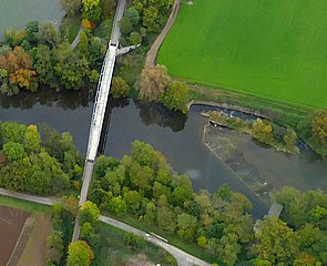
| Description |
Dieses Bild zeigt die Abzweigung des Salinenkanals. |
| Date | |
| Source | |
| Author | Rolf Kickuth |

| Object location | | View this and other nearby images on: OpenStreetMap |
|---|
Licensing edit
I, the copyright holder of this work, hereby publish it under the following license:
This file is licensed under the Creative Commons Attribution-Share Alike 4.0 International license.
- You are free:
- to share – to copy, distribute and transmit the work
- to remix – to adapt the work
- Under the following conditions:
- attribution – You must give appropriate credit, provide a link to the license, and indicate if changes were made. You may do so in any reasonable manner, but not in any way that suggests the licensor endorses you or your use.
- share alike – If you remix, transform, or build upon the material, you must distribute your contributions under the same or compatible license as the original.
File history
Click on a date/time to view the file as it appeared at that time.
| Date/Time | Thumbnail | Dimensions | User | Comment | |
|---|---|---|---|---|---|
| current | 16:29, 8 March 2021 | | 1,261 × 1,025 (872 KB) | Sarang (talk | contribs) | {{Information |Description=Dieses Bild zeigt die Abzweigung des Salinenkanals.<br> Der Kocher fließt von links nach rechts, und wird von der Brücke der ehemaligen Kochertalbahn überspannt.<br> Links außerhalb des Bildes liegt Hagenbach, oberhalb beginnt der Freizeitpark.<br> In der rechten Bildhälfte ist zu sehen, wie der Wasserstand durch eine Stauanlage reguliert wird.<br> Links davon (oberhalb) befindet sich eine Fischtreppe, rechts (unten) ist das Wehr am Beginn des Kanals zu sehen.... |
You cannot overwrite this file.
File usage on Commons
The following 2 pages use this file: