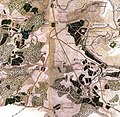
File:Kolomenskoye, Chertanovo, Biryulyovo in 1818.jpg

Original file (1,000 × 974 pixels, file size: 401 KB, MIME type: image/jpeg)
Captions
Captions
Summary edit
| DescriptionKolomenskoye, Chertanovo, Biryulyovo in 1818.jpg |
Русский: Топографическая карта окружности Москвы, 1818 год, фрагмент: территория современных Коломенского, Чертанова, Бирюлёва, Царицына |
| Date | |
| Source | Топографическая карта окружности Москвы, Военно-топографическое депо, 1823 год |
| Creator |
Офицеры Квартирмейстерской части, снята в 1818 году |
| Georeferencing | Georeference the map in Wikimaps Warper If inappropriate please set warp_status = skip to hide. |
Licensing edit
| Public domainPublic domainfalsefalse |
|
This work is in the public domain in its country of origin and other countries and areas where the copyright term is the author's life plus 70 years or fewer. This work is in the public domain in the United States because it was published (or registered with the U.S. Copyright Office) before January 1, 1929. | |
| This file has been identified as being free of known restrictions under copyright law, including all related and neighboring rights. | |
https://creativecommons.org/publicdomain/mark/1.0/PDMCreative Commons Public Domain Mark 1.0falsefalse
File history
Click on a date/time to view the file as it appeared at that time.
| Date/Time | Thumbnail | Dimensions | User | Comment | |
|---|---|---|---|---|---|
| current | 10:12, 30 August 2018 |  | 1,000 × 974 (401 KB) | Nikolay Omonov (talk | contribs) | User created page with UploadWizard |
You cannot overwrite this file.
File usage on Commons
The following page uses this file:
File usage on other wikis
The following other wikis use this file:
- Usage on ru.wikipedia.org
Metadata
This file contains additional information such as Exif metadata which may have been added by the digital camera, scanner, or software program used to create or digitize it. If the file has been modified from its original state, some details such as the timestamp may not fully reflect those of the original file. The timestamp is only as accurate as the clock in the camera, and it may be completely wrong.
| User comments | CREATOR: gd-jpeg v1.0 (using IJG JPEG v62), default quality |
|---|