File:Kongerigske-Enklaver.png

Size of this preview: 332 × 599 pixels. Other resolutions: 133 × 240 pixels | 428 × 772 pixels.
Original file (428 × 772 pixels, file size: 62 KB, MIME type: image/png)
Captions
Captions
Add a one-line explanation of what this file represents
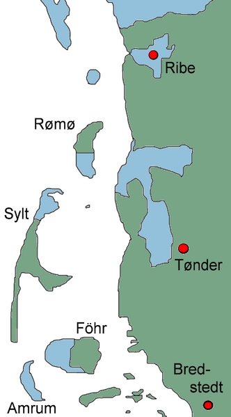
The map shows the so-called Royal Enclaves before 1864. These areas were administred as integral parts of the Kingdom of Denmark although located within the Duchy of Schleswig.
Map drawn by Lars Helbo
| This work has been released into the public domain by its author, Lars Helbo. This applies worldwide. In some countries this may not be legally possible; if so: |
File history
Click on a date/time to view the file as it appeared at that time.
| Date/Time | Thumbnail | Dimensions | User | Comment | |
|---|---|---|---|---|---|
| current | 15:21, 24 August 2005 | | 428 × 772 (62 KB) | Lars Helbo~commonswiki (talk | contribs) |
You cannot overwrite this file.
File usage on Commons
There are no pages that use this file.
File usage on other wikis
The following other wikis use this file:
- Usage on de.wikipedia.org
- Usage on sv.wikipedia.org