File:Kopuatai peat dome.jpg
No higher resolution available.
Kopuatai_peat_dome.jpg (552 × 501 pixels, file size: 38 KB, MIME type: image/jpeg)
Captions
Captions
Add a one-line explanation of what this file represents
Summary edit
| Description |
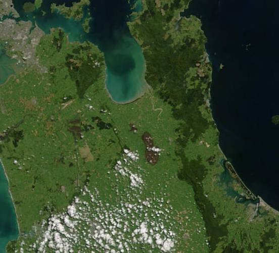
English: Section of North Island of New Zealand centred on the Hauraki Plains. Auckland is at the top left, Tauranga bottom right. The Kopuatai peat dome is the footprint-shaped brown area centre. |
| Date | |
| Source | http://earthobservatory.nasa.gov/images/imagerecords/3000/3101/NewZealand_TMO2002296_lrg.jpg |
| Author | Jacques Descloitres, MODIS Land Rapid Response Team at NASA GSFC |
Licensing edit
| This file is in the public domain in the United States because it was solely created by NASA. NASA copyright policy states that "NASA material is not protected by copyright unless noted". (See Template:PD-USGov, NASA copyright policy page or JPL Image Use Policy.) | ||
 |
Warnings:
|
File history
Click on a date/time to view the file as it appeared at that time.
| Date/Time | Thumbnail | Dimensions | User | Comment | |
|---|---|---|---|---|---|
| current | 21:25, 8 January 2011 | | 552 × 501 (38 KB) | Dramatic (talk | contribs) | {{Information |Description={{en|1=Section of North Island of New Zealand centred on the Hauraki Plains. Auckland is at the top left, Tauranga bottom right. The Kopuatai peat dome is the footprint-shaped brown area centre.}} |Source=http://earthobservatory |
You cannot overwrite this file.
File usage on Commons
There are no pages that use this file.
File usage on other wikis
The following other wikis use this file:
- Usage on en.wikipedia.org
- Usage on es.wikipedia.org
- Usage on www.wikidata.org