File:Korea map 1939-es.svg

Size of this PNG preview of this SVG file: 634 × 387 pixels. Other resolutions: 320 × 195 pixels | 640 × 391 pixels | 1,024 × 625 pixels | 1,280 × 781 pixels | 2,560 × 1,563 pixels.
Original file (SVG file, nominally 634 × 387 pixels, file size: 1.31 MB)
Captions
Captions
Add a one-line explanation of what this file represents
Summary edit
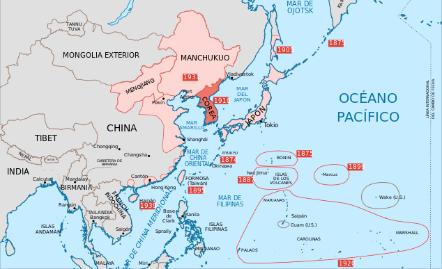
| Description |
English: Map of 1939, showing Colonial Korea (highlighted), and other Japanese territories and colonies, under rule of the Empire of Japan. |
| Date | |
| Source | Korea map 1939.svg |
| Author |
Mengjiang map 1939-es.svg: Rowanwindwhistler (talk · contribs) Korea map 1939.svg: Emok (talk · contribs)
|
| Other versions |
|


Licensing edit
This file is licensed under the Creative Commons Attribution-Share Alike 3.0 Unported license.
Attribution: GFDL
- You are free:
- to share – to copy, distribute and transmit the work
- to remix – to adapt the work
- Under the following conditions:
- attribution – You must give appropriate credit, provide a link to the license, and indicate if changes were made. You may do so in any reasonable manner, but not in any way that suggests the licensor endorses you or your use.
- share alike – If you remix, transform, or build upon the material, you must distribute your contributions under the same or compatible license as the original.
File history
Click on a date/time to view the file as it appeared at that time.
| Date/Time | Thumbnail | Dimensions | User | Comment | |
|---|---|---|---|---|---|
| current | 23:50, 1 June 2023 | | 634 × 387 (1.31 MB) | SmallJarsWithGreenLabels (talk | contribs) | saipan per user:Geographyinitiative |
| 19:16, 6 September 2016 |  | 634 × 387 (1.32 MB) | Rowanwindwhistler (talk | contribs) | User created page with UploadWizard |
You cannot overwrite this file.
File usage on Commons
The following 4 pages use this file:
File usage on other wikis
The following other wikis use this file:
- Usage on eu.wikipedia.org