File:Korutánske vojvodstvo.png

Size of this preview: 582 × 600 pixels. Other resolutions: 233 × 240 pixels | 466 × 480 pixels | 745 × 768 pixels | 994 × 1,024 pixels | 1,987 × 2,048 pixels | 4,091 × 4,216 pixels.
Original file (4,091 × 4,216 pixels, file size: 3.92 MB, MIME type: image/png)
Captions
Captions
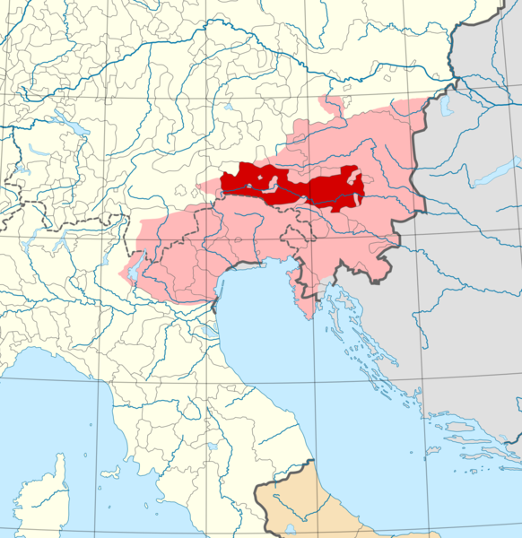
Duchy of Carinthia
Summary edit
| Description |
Slovenčina: Mapa Svätej ríše rímskej v polovici 13. storočia, tmavočervenou územie vlastného Korutánska v danom období, svetločervenou rozsah Korutánskeho vojvodstva pred rokom 1000, t.j. v období najväčšieho rozsahu panstva
English: Map of the Holy Roman Empire in the half 13th century, the dark red territory of Carinthia proper in that period, the light red extent of the Duchy of Carinthia before 1000, i. during most extensive dominion |
| Date | |
| Source | File:Holy_Roman_Empire_1250_(location_map_scheme).svg |
| Author | Alphathon |
.svg)
Licensing edit
This file is licensed under the Creative Commons Attribution-Share Alike 4.0 International license.
- You are free:
- to share – to copy, distribute and transmit the work
- to remix – to adapt the work
- Under the following conditions:
- attribution – You must give appropriate credit, provide a link to the license, and indicate if changes were made. You may do so in any reasonable manner, but not in any way that suggests the licensor endorses you or your use.
- share alike – If you remix, transform, or build upon the material, you must distribute your contributions under the same or compatible license as the original.
File history
Click on a date/time to view the file as it appeared at that time.
| Date/Time | Thumbnail | Dimensions | User | Comment | |
|---|---|---|---|---|---|
| current | 15:22, 24 March 2020 | | 4,091 × 4,216 (3.92 MB) | Robert Jahoda (talk | contribs) | Uploaded a work by Alphathon from https://commons.wikimedia.org/wiki/File:Holy_Roman_Empire_1250_(location_map_scheme).svg with UploadWizard |
You cannot overwrite this file.
File usage on Commons
There are no pages that use this file.
File usage on other wikis
The following other wikis use this file:
- Usage on sk.wikipedia.org