File:L'Historiographie du royaume de France (BM 1893,0331.109).jpg

Original file (2,500 × 1,957 pixels, file size: 1.26 MB, MIME type: image/jpeg)
Captions
Captions
Summary edit
.jpg&action=edit§ion=1)
| L'Historiographie du royaume de France
( |
||||||||||||||||||||||||
|---|---|---|---|---|---|---|---|---|---|---|---|---|---|---|---|---|---|---|---|---|---|---|---|---|
| Title |
L'Historiographie du royaume de France |
|||||||||||||||||||||||
| Description |
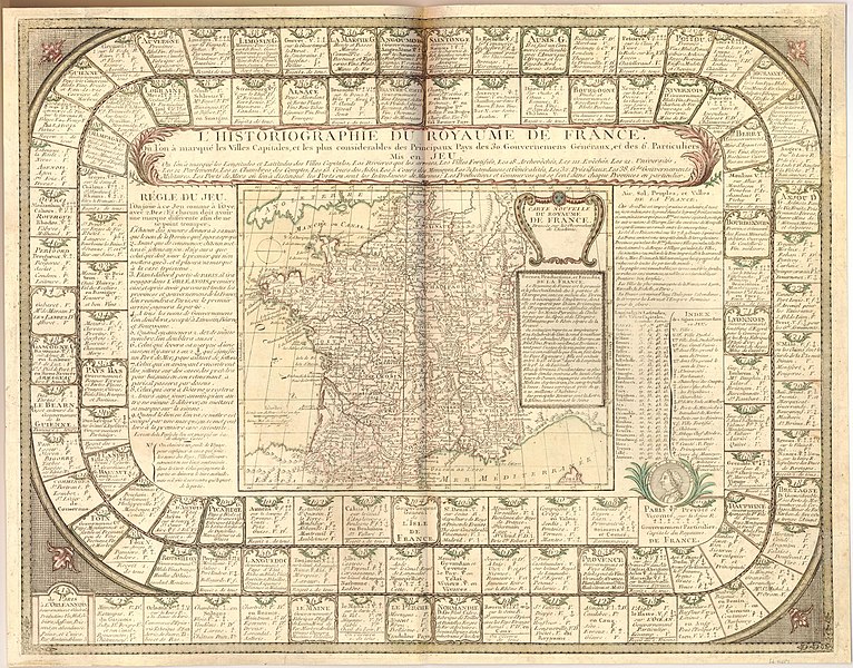
English: Game board with numbered compartments from 1 to 108 arranged in a spiral, the more elaborate compartments bearing a cartouche with the name of a region in France, beneath which are listed its principal industries, the subsequent compartments containing lists of its principal cities and towns, with a key to their status, the final compartment being Paris, surmounted by a portrait medaillion of Louis XV. In the centre, a map of France, showing all the towns mentioned in the game, above which is the title and a description of the map; to the left of the map, the rules, to the right, a description of the "Air, Sol, Peuples, et Villes" of France, the longitudes and latitudes of the principal towns, and a key.
Hand-coloured etching |
|||||||||||||||||||||||
| Date | between 1744 and 1768 | |||||||||||||||||||||||
| Medium | paper | |||||||||||||||||||||||
| Dimensions |
|
|||||||||||||||||||||||
| Collection |
|
|||||||||||||||||||||||
| Current location |
Prints and Drawings |
|||||||||||||||||||||||
| Accession number |
1893,0331.109 |
|||||||||||||||||||||||
| Source/Photographer | https://www.britishmuseum.org/collection/object/P_1893-0331-109 | |||||||||||||||||||||||
| Permission (Reusing this file) |
© The Trustees of the British Museum, released as CC BY-NC-SA 4.0 | |||||||||||||||||||||||
Licensing edit
.jpg&action=edit§ion=2)
This image is in the public domain because it is a mere mechanical scan or photocopy of a public domain original, or – from the available evidence – is so similar to such a scan or photocopy that no copyright protection can be expected to arise. The original itself is in the public domain for the following reason:
This tag is designed for use where there may be a need to assert that any enhancements (eg brightness, contrast, colour-matching, sharpening) are in themselves insufficiently creative to generate a new copyright. It can be used where it is unknown whether any enhancements have been made, as well as when the enhancements are clear but insufficient. For known raw unenhanced scans you can use an appropriate {{PD-old}} tag instead. For usage, see Commons:When to use the PD-scan tag.  | ||||
File history
Click on a date/time to view the file as it appeared at that time.
| Date/Time | Thumbnail | Dimensions | User | Comment | |
|---|---|---|---|---|---|
| current | 18:08, 15 May 2020 | | 2,500 × 1,957 (1.26 MB) | Copyfraud (talk | contribs) | British Museum public domain uploads (Copyfraud/BM) Maps in the British Museum 1744 #87/703 |
You cannot overwrite this file.
File usage on Commons
The following page uses this file:
.jpg)
.jpg&oldid=850596457)