File:L'estuaire de la Gironde.jpg
Original file (3,648 × 2,432 pixels, file size: 1.01 MB, MIME type: image/jpeg)
Captions
Summary edit
DescriptionL'estuaire de la Gironde.jpg |
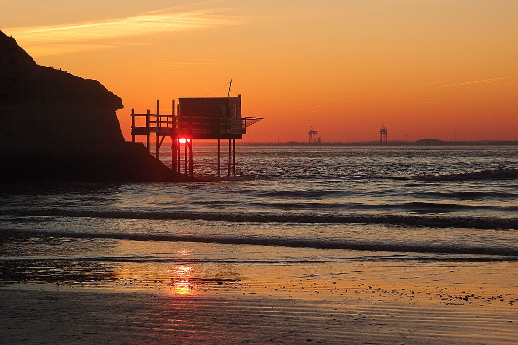
Français : Le soleil se couche derrière un carrelet à Meschers sur Gironde. De l'autre côté de l'estuaire, la pointe du Verdon et les grues de son port. |
Date | |
Source | Own work |
Author | Jfda |
Camera location | 45° 33′ 52.36″ N, 0° 58′ 19.01″ W | View this and other nearby images on: OpenStreetMap | 45.564545; -0.971947 |
---|
Licensing edit
- You are free:
- to share – to copy, distribute and transmit the work
- to remix – to adapt the work
- Under the following conditions:
- attribution – You must give appropriate credit, provide a link to the license, and indicate if changes were made. You may do so in any reasonable manner, but not in any way that suggests the licensor endorses you or your use.
- share alike – If you remix, transform, or build upon the material, you must distribute your contributions under the same or compatible license as the original.
This image was uploaded as part of Wiki Loves Earth 2015.
aragonés | العربية | asturianu | azərbaycanca | беларуская (тарашкевіца) | български | বাংলা | brezhoneg | català | čeština | Cymraeg | Deutsch | Ελληνικά | English | español | eesti | euskara | فارسی | français | galego | עברית | hrvatski | հայերեն | Bahasa Indonesia | italiano | 日本語 | ქართული | 한국어 | latviešu | македонски | മലയാളം | मराठी | Bahasa Melayu | norsk bokmål | नेपाली | Nederlands | norsk | polski | português | português do Brasil | русский | sicilianu | shqip | slovenščina | српски / srpski | svenska | ไทย | Türkçe | українська | اردو | 中文 | 中文(台灣) | +/− |
File history
Click on a date/time to view the file as it appeared at that time.
Date/Time | Thumbnail | Dimensions | User | Comment | |
---|---|---|---|---|---|
current | 07:40, 9 May 2015 | 3,648 × 2,432 (1.01 MB) | Jfda (talk | contribs) | User created page with UploadWizard |
You cannot overwrite this file.
File usage on Commons
The following 2 pages use this file:
File usage on other wikis
The following other wikis use this file:
- Usage on fr.wikipedia.org
Metadata
This file contains additional information such as Exif metadata which may have been added by the digital camera, scanner, or software program used to create or digitize it. If the file has been modified from its original state, some details such as the timestamp may not fully reflect those of the original file. The timestamp is only as accurate as the clock in the camera, and it may be completely wrong.
Camera manufacturer | OLYMPUS IMAGING CORP. |
---|---|
Camera model | XZ-1 |
Exposure time | 1/800 sec (0.00125) |
F-number | f/4 |
ISO speed rating | 100 |
Date and time of data generation | 17:21, 27 December 2011 |
Lens focal length | 24 mm |
Latitude | 45° 33′ 52.36″ N |
Longitude | 0° 58′ 19.01″ W |
Altitude | 11 meters above sea level |
Image title |
|
City shown | Meschers |
Horizontal resolution | 240 dpi |
Vertical resolution | 240 dpi |
Software used | Adobe Photoshop Lightroom 3.6 (Windows) |
File change date and time | 07:02, 9 May 2015 |
Exposure Program | Creative program (biased toward depth of field) |
Exif version | 2.3 |
Date and time of digitizing | 17:21, 27 December 2011 |
APEX shutter speed | 9.643856 |
APEX aperture | 4 |
APEX exposure bias | 0 |
Maximum land aperture | 1.7 APEX (f/1.8) |
Subject distance | 207 meters |
Metering mode | Pattern |
Light source | Cloudy weather |
Flash | Flash did not fire, auto mode |
File source | Digital still camera |
Custom image processing | Custom process |
Exposure mode | Auto exposure |
White balance | Manual white balance |
Digital zoom ratio | 1 |
Focal length in 35 mm film | 112 mm |
Scene capture type | Standard |
Scene control | None |
Contrast | Normal |
Saturation | High saturation |
Sharpness | Hard |
GPS time (atomic clock) | 17:21 |
Geodetic survey data used | WGS-84 |
GPS date | 27 December 2011 |
GPS tag version | 0.0.2.2 |
Serial number of camera | AAN506914 |
Date metadata was last modified | 09:02, 9 May 2015 |
Rating (out of 5) | 5 |
Unique ID of original document | xmp.did:FA90EFE37A3EE111B2FB959730E5DA54 |
Code for country shown | FR |
Sublocation of city shown | Plage des Vergnes |
Country shown | France |
Province or state shown | Poitou-Charentes |
IIM version | 4 |