File:LaColoba-de.svg

Size of this PNG preview of this SVG file: 800 × 533 pixels. Other resolutions: 320 × 213 pixels | 640 × 426 pixels | 1,024 × 682 pixels | 1,280 × 853 pixels | 2,560 × 1,706 pixels.
Original file (SVG file, nominally 800 × 533 pixels, file size: 232 KB)
Captions
Captions
Add a one-line explanation of what this file represents
Summary edit
| Description |
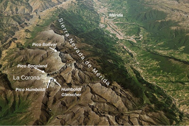
English: labeled 3D-Image of en:Sierra Nevada de Merida, NASA Earth Observatory images by Joshua Stevens, using Landsat data from the U.S. Geological Survey and topographic data from the Shuttle Radar Topography Mission (SRTM). |
| Date | |
| Source |
This file was derived from: 2015006 SierraNevadaDeMerida lrg.jpg |
| Author | Original map: Joshua Stevens, NASA Earth Observatory, using Landsat data from the U.S. Geological Survey and topographic data from the Shuttle Radar Topography Mission (SRTM); Text added by User:DeWikiMan |
Licensing edit
This work is based on a work in the public domain. It has been digitally enhanced and/or modified. This derivative work has been (or is hereby) released into the public domain by its author, DeWikiMan. This applies worldwide.
In some countries this may not be legally possible; if so: |
File history
Click on a date/time to view the file as it appeared at that time.
| Date/Time | Thumbnail | Dimensions | User | Comment | |
|---|---|---|---|---|---|
| current | 00:20, 20 November 2018 | | 800 × 533 (232 KB) | DeWikiMan (talk | contribs) | typo fixed |
| 00:15, 20 November 2018 |  | 800 × 533 (232 KB) | DeWikiMan (talk | contribs) | Reverted to version as of 00:11, 20 November 2018 (UTC) | |
| 00:14, 20 November 2018 |  | 800 × 533 (200 KB) | DeWikiMan (talk | contribs) | it seems the Wiki-Renderer doesn't like curved text | |
| 00:11, 20 November 2018 |  | 800 × 533 (232 KB) | DeWikiMan (talk | contribs) | name of Sierra got lost | |
| 00:08, 20 November 2018 |  | 800 × 533 (200 KB) | DeWikiMan (talk | contribs) | {{Information |description ={{en|1=labelled 3D-Image of en:Sierra Nevada de Merida, NASA Earth Observatory images by Joshua Stevens, using Landsat data from the U.S. Geological Survey and topographic data from the Shuttle Radar Topography Mission (SRTM).}} |date =2018-11-20 |source ={{Derived from |1=2015006 SierraNevadaDeMerida lrg.jpg}} |author =Original map: Joshua Stevens, NASA Earth Observatory, using Landsat data from the U.S. Geological Survey and topograp... |
You cannot overwrite this file.
File usage on Commons
There are no pages that use this file.
File usage on other wikis
The following other wikis use this file:
- Usage on de.wikipedia.org