File:La Payunia.jpg
Size of this preview: 800 × 450 pixels. Other resolutions: 320 × 180 pixels | 640 × 360 pixels | 1,024 × 576 pixels | 1,280 × 720 pixels | 2,613 × 1,470 pixels.
Original file (2,613 × 1,470 pixels, file size: 1.83 MB, MIME type: image/jpeg)
File information
Structured data
Captions
Summary edit
DescriptionLa Payunia.jpg |
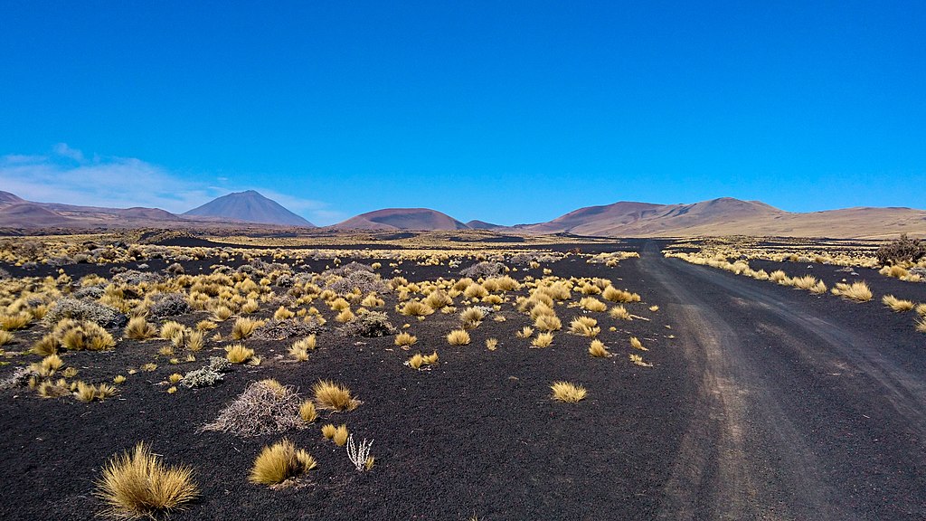
English: Landscape in the natural reserve La Payunia, Mendoza province, Argentina, with the stratovolcano known as Payún Liso in the background, part of the wider Payún Matrú Volcanic Field. |
||
Date | |||
Source | Self-photographed | ||
Author | Maximilian Reininghaus | ||
Permission (Reusing this file) |
|
Camera location | 36° 19′ 56.13″ S, 69° 24′ 57.71″ W | View this and other nearby images on: OpenStreetMap | -36.332257; -69.416031 |
---|
File history
Click on a date/time to view the file as it appeared at that time.
Date/Time | Thumbnail | Dimensions | User | Comment | |
---|---|---|---|---|---|
current | 14:59, 29 March 2020 | 2,613 × 1,470 (1.83 MB) | Maximilian Reininghaus (talk | contribs) | {{Information |description ={{en|1=Landscape in the natural reserve La Payunia, Mendoza province, Argentina, with the volcano Payún Matrú in the background}} |date =2019-09-05 |source ={{own}} |author =User:Maximilian Reininghaus |permission ={{FAL-1.3}} }} {{GPS EXIF}} Category:Reserva Provincial La Payunia Category:Payun Matru |
You cannot overwrite this file.
File usage on Commons
The following 3 pages use this file:
File usage on other wikis
The following other wikis use this file:
- Usage on es.wikipedia.org
Metadata
This file contains additional information such as Exif metadata which may have been added by the digital camera, scanner, or software program used to create or digitize it. If the file has been modified from its original state, some details such as the timestamp may not fully reflect those of the original file. The timestamp is only as accurate as the clock in the camera, and it may be completely wrong.
Camera manufacturer | SONY |
---|---|
Camera model | E6653 |
Exposure time | 1/2,000 sec (0.0005) |
F-number | f/2 |
ISO speed rating | 40 |
Date and time of data generation | 13:01, 5 September 2019 |
Lens focal length | 4.23 mm |
Latitude | 36° 19′ 56.13″ S |
Longitude | 69° 24′ 57.71″ W |
Altitude | 2,097 meters above sea level |
Width | 2,613 px |
Height | 1,470 px |
Bits per component | 8 |
Compression scheme | Uncompressed |
Pixel composition | RGB |
Orientation | Normal |
Number of components | 3 |
Horizontal resolution | 300 dpi |
Vertical resolution | 300 dpi |
Data arrangement | chunky format |
Software used | RawTherapee 5.8 |
File change date and time | 13:01, 5 September 2019 |
Exif version | 2.2 |
Date and time of digitizing | 13:01, 5 September 2019 |
APEX shutter speed | 10.96 |
APEX exposure bias | 0 |
Metering mode | Pattern |
Light source | Unknown |
Flash | Flash did not fire, compulsory flash suppression |
DateTime subseconds | 732045 |
DateTimeOriginal subseconds | 732045 |
DateTimeDigitized subseconds | 732045 |
Custom image processing | Normal process |
Exposure mode | Auto exposure |
White balance | Auto white balance |
Digital zoom ratio | 1 |
Scene capture type | Landscape |
Subject distance range | Unknown |
GPS time (atomic clock) | 16:01 |
Receiver status | Measurement in progress |
Geodetic survey data used | WGS-84 |
GPS date | 5 September 2019 |
GPS tag version | 0.0.2.2 |