File:La palma volcano.jpg

Size of this preview: 800 × 545 pixels. Other resolutions: 320 × 218 pixels | 640 × 436 pixels | 1,024 × 697 pixels | 1,280 × 871 pixels | 2,560 × 1,743 pixels | 3,032 × 2,064 pixels.
Original file (3,032 × 2,064 pixels, file size: 865 KB, MIME type: image/jpeg)
Captions
Captions
Add a one-line explanation of what this file represents
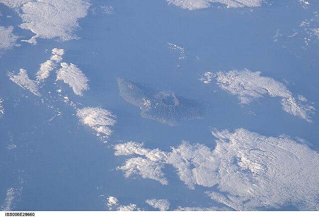
| Description | Satellite photo of La Palma, Canary Islands. (North is in the lower right.) The grand crater in the center is the Caldera de Taburiente. The Cumbre Vieja is a ridge to the South (upper left) of the caldera. |
| Date | |
| Source | http://eol.jsc.nasa.gov/scripts/sseop/photo.pl?mission=ISS006&roll=E&frame=29660 |
| Author | Image Science and Analysis Laboratory, NASA-Johnson Space Center. |
| Other versions | La Palma in Canary Islands - ISS satellite image ISS006-E-29660 - cropped.jpg |
This image or video was catalogued by Johnson Space Center of the United States National Aeronautics and Space Administration (NASA) under Photo ID: ISS006-E-29660. This tag does not indicate the copyright status of the attached work. A normal copyright tag is still required. See Commons:Licensing. Other languages:
|
| This file is in the public domain in the United States because it was solely created by NASA. NASA copyright policy states that "NASA material is not protected by copyright unless noted". (See Template:PD-USGov, NASA copyright policy page or JPL Image Use Policy.) | ||
 |
Warnings:
|
File history
Click on a date/time to view the file as it appeared at that time.
| Date/Time | Thumbnail | Dimensions | User | Comment | |
|---|---|---|---|---|---|
| current | 13:47, 20 October 2021 | | 3,032 × 2,064 (865 KB) | GeoWriter (talk | contribs) | higher resolution version (3032 x 2064 pixels) |
| 21:46, 19 September 2006 |  | 639 × 423 (50 KB) | Erina (talk | contribs) | ||
| 05:15, 30 December 2004 |  | 639 × 435 (56 KB) | Clngre~commonswiki (talk | contribs) | Satellite photo of Cumbre Vieja, La Palma, Canary Islands. Volcano {{PD-USGov-NASA}} |
You cannot overwrite this file.
File usage on Commons
The following 2 pages use this file:
- La Palma
- File:ISS006-E-29660 - View of the Canary Islands.jpg (file redirect)
File usage on other wikis
The following other wikis use this file:
- Usage on be-tarask.wikipedia.org
- Usage on de.wikipedia.org
- Usage on eo.wikipedia.org
- Usage on frr.wikipedia.org
- Usage on ja.wikipedia.org
- Usage on pl.wikipedia.org
- Usage on pt.wikipedia.org
- Usage on sv.wikipedia.org