File:Lageplan Stahlhausen.jpg

Size of this preview: 800 × 559 pixels. Other resolutions: 320 × 224 pixels | 640 × 447 pixels | 1,024 × 716 pixels | 1,280 × 895 pixels | 1,647 × 1,151 pixels.
Original file (1,647 × 1,151 pixels, file size: 1.43 MB, MIME type: image/jpeg)
Captions
Captions
Add a one-line explanation of what this file represents
Summary edit
| Description |
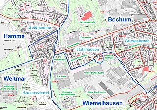
Deutsch: Karte von Bochum. Hier sind die Grenzen der Gemarkungen Bochum, Wiemelhausen, Weitmar und Hamme im Bereich von Stahlhausen eingezeichnet. Weiterhin die umgangssprachlichen Namen einzelner Teile, sowie die Angabe von Bauten. |
| Date | |
| Source | Geoportal der Stadt Bochum |
| Author | Stadtplanwerk Ruhrgebiet 2.0 © Regionalverband Ruhr und Kooperationspartner (Datenlizenz Deutschland - Namensnennung - Version 2.0), Datengrundlagen: ALKIS, ATKIS - Land NRW/Katasterämter (Datenlizenz Deutschland - Zero - Version 2.0) und © OpenStreetMap - Mitwirkende (License: Open Database License) | Datenlizenz Deutschland – Zero – Version 2.0 |
| Permission (Reusing this file) |
dl-de/by-2-0 Datenlizenz Deutschland - Namensnennung – Version 2.0 |
Licensing edit

|
This file is licensed under the terms of the Data licence Germany – attribution – version 2.0 |
|
You are free:
Under the following conditions:
|
File history
Click on a date/time to view the file as it appeared at that time.
| Date/Time | Thumbnail | Dimensions | User | Comment | |
|---|---|---|---|---|---|
| current | 14:11, 6 March 2023 | | 1,647 × 1,151 (1.43 MB) | Heinrich Kämpchen (talk | contribs) | Uploaded a work by Stadtplanwerk Ruhrgebiet 2.0 © Regionalverband Ruhr und Kooperationspartner (Datenlizenz Deutschland - Namensnennung - Version 2.0), Datengrundlagen: ALKIS, ATKIS - Land NRW/Katasterämter (Datenlizenz Deutschland - Zero - Version 2.0) und © OpenStreetMap - Mitwirkende (License: Open Database License) | Datenlizenz Deutschland – Zero – Version 2.0 from Geoportal der Stadt Bochum with UploadWizard |
You cannot overwrite this file.
File usage on Commons
There are no pages that use this file.
File usage on other wikis
The following other wikis use this file:
- Usage on de.wikipedia.org