File:Lageplan von Burg Peiting, Burgstall Schlossberg (Schongau) und Abschnittsbefestigung Peiting.PNG

Size of this preview: 800 × 329 pixels. Other resolutions: 320 × 132 pixels | 953 × 392 pixels.
Original file (953 × 392 pixels, file size: 963 KB, MIME type: image/png)
Captions
Captions
Add a one-line explanation of what this file represents
Summary edit
_und_Abschnittsbefestigung_Peiting.PNG&action=edit§ion=1)
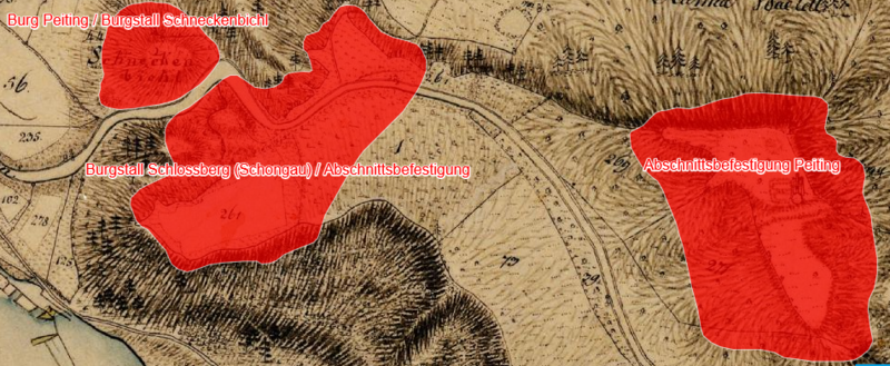
| Description | Lageplan von Burg Peiting, Burgstall Schlossberg (Schongau) und Abschnittsbefestigung Peiting auf dem Urkataster von Bayern |
| Date | circa 1830 |
| Source | Geobasisdaten: Bayerische Vermessungsverwaltung |
| Author | Königreich Bayern |
| Permission (Reusing this file) |
CC BY-ND 3.0 DE |
Licensing edit
_und_Abschnittsbefestigung_Peiting.PNG&action=edit§ion=2)
|
This work is in the public domain in its country of origin and other countries and areas where the copyright term is the author's life plus 100 years or fewer. This work is in the public domain in the United States because it was published (or registered with the U.S. Copyright Office) before January 1, 1929. | |
| This file has been identified as being free of known restrictions under copyright law, including all related and neighboring rights. | |
File history
Click on a date/time to view the file as it appeared at that time.
| Date/Time | Thumbnail | Dimensions | User | Comment | |
|---|---|---|---|---|---|
| current | 08:23, 20 June 2023 | 953 × 392 (963 KB) | Luckyprof (talk | contribs) | {{Information |Description=Lageplan von Burg Peiting, Burgstall Schlossberg (Schongau) und Abschnittsbefestigung Peiting auf dem Urkataster von Bayern |Source=Geobasisdaten: Bayerische Vermessungsverwaltung |Date=etwa 1830 |Author=Königreich Bayern |Permission=CC BY-ND 3.0 DE |other_versions= }} Category:Schongau |
You cannot overwrite this file.
File usage on Commons
The following page uses this file:
File usage on other wikis
The following other wikis use this file:
- Usage on de.wikipedia.org
_und_Abschnittsbefestigung_Peiting.PNG&oldid=776324144)