File:Lake Erie Islands Map.png

Size of this preview: 800 × 561 pixels. Other resolutions: 320 × 225 pixels | 640 × 449 pixels | 1,024 × 719 pixels | 1,160 × 814 pixels.
Original file (1,160 × 814 pixels, file size: 47 KB, MIME type: image/png)
Captions
Captions
Add a one-line explanation of what this file represents
Summary edit
| Description |
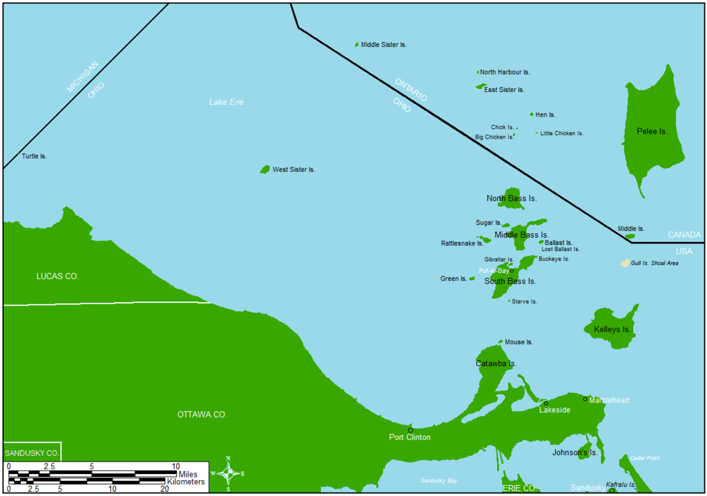
English: Map showing a majority of the Lake Erie islands that lie between Toledo and Cleveland.
|
| Date | |
| Source | Drawn in ArcMap and Microsoft Paint |
| Author | Frank12 |
Licensing edit
Frank12 at English Wikipedia, the copyright holder of this work, hereby publishes it under the following licenses:

|
Permission is granted to copy, distribute and/or modify this document under the terms of the GNU Free Documentation License, Version 1.2 or any later version published by the Free Software Foundation; with no Invariant Sections, no Front-Cover Texts, and no Back-Cover Texts. A copy of the license is included in the section entitled GNU Free Documentation License. |
This file is licensed under the Creative Commons Attribution-Share Alike 3.0 Unported license.
Attribution: Frank12 at English Wikipedia
- You are free:
- to share – to copy, distribute and transmit the work
- to remix – to adapt the work
- Under the following conditions:
- attribution – You must give appropriate credit, provide a link to the license, and indicate if changes were made. You may do so in any reasonable manner, but not in any way that suggests the licensor endorses you or your use.
- share alike – If you remix, transform, or build upon the material, you must distribute your contributions under the same or compatible license as the original.
You may select the license of your choice.
Original upload log edit
The original description page was here. All following user names refer to en.wikipedia.
| Date/Time | Dimensions | User | Comment |
|---|---|---|---|
| 2014-03-19 11:41 | 1160×814× (65335 bytes) | Frank12 | Added Kafralu Island and labeled Sandusky County. |
| 2014-03-10 12:14 | 1160×814× (63558 bytes) | Frank12 | Added Put-in-Bay, a scale, and a north arrow. |
| 2014-03-10 12:10 | 1160×814× (54384 bytes) | Frank12 | Area expanded to include Turtle Island. |
| 2014-03-06 15:02 | 1232×873× (56674 bytes) | Frank12 | Labeled Catawba Island, Lakeside, and Marblehead. |
| 2014-03-06 14:41 | 1232×873× (54446 bytes) | Frank12 | Uploading a self-made file using [[Wikipedia:File_Upload_Wizard|File Upload Wizard]] |
File history
Click on a date/time to view the file as it appeared at that time.
| Date/Time | Thumbnail | Dimensions | User | Comment | |
|---|---|---|---|---|---|
| current | 12:46, 12 July 2018 | | 1,160 × 814 (47 KB) | Frank12 (talk | contribs) | Adjusted scale bar to show measurements in both Miles and Kilometers, and added a North Star with the four cardinal directions. |
| 04:07, 3 June 2016 |  | 1,160 × 814 (64 KB) | OgreBot (talk | contribs) | (BOT): Reverting to most recent version before archival | |
| 04:07, 3 June 2016 |  | 1,160 × 814 (62 KB) | OgreBot (talk | contribs) | (BOT): Uploading old version of file from en.wikipedia; originally uploaded on 2014-03-10 12:14:45 by Frank12 | |
| 04:07, 3 June 2016 |  | 1,160 × 814 (53 KB) | OgreBot (talk | contribs) | (BOT): Uploading old version of file from en.wikipedia; originally uploaded on 2014-03-10 12:10:33 by Frank12 | |
| 04:07, 3 June 2016 |  | 1,232 × 873 (55 KB) | OgreBot (talk | contribs) | (BOT): Uploading old version of file from en.wikipedia; originally uploaded on 2014-03-06 15:02:58 by Frank12 | |
| 04:06, 3 June 2016 |  | 1,232 × 873 (53 KB) | OgreBot (talk | contribs) | (BOT): Uploading old version of file from en.wikipedia; originally uploaded on 2014-03-06 14:41:48 by Frank12 | |
| 04:29, 25 April 2016 |  | 1,160 × 814 (64 KB) | FastilyClone (talk | contribs) | Transferred from enwp |
You cannot overwrite this file.
File usage on Commons
There are no pages that use this file.
File usage on other wikis
The following other wikis use this file:
- Usage on en.wikipedia.org
- Usage on fr.wikipedia.org
- Usage on ru.wikipedia.org