File:Lake Urmia (MODIS 2016-07-06).jpg

Original file (3,620 × 2,612 pixels, file size: 1.21 MB, MIME type: image/jpeg)
Captions
Captions
Summary edit
.jpg&action=edit§ion=1)
| Description |
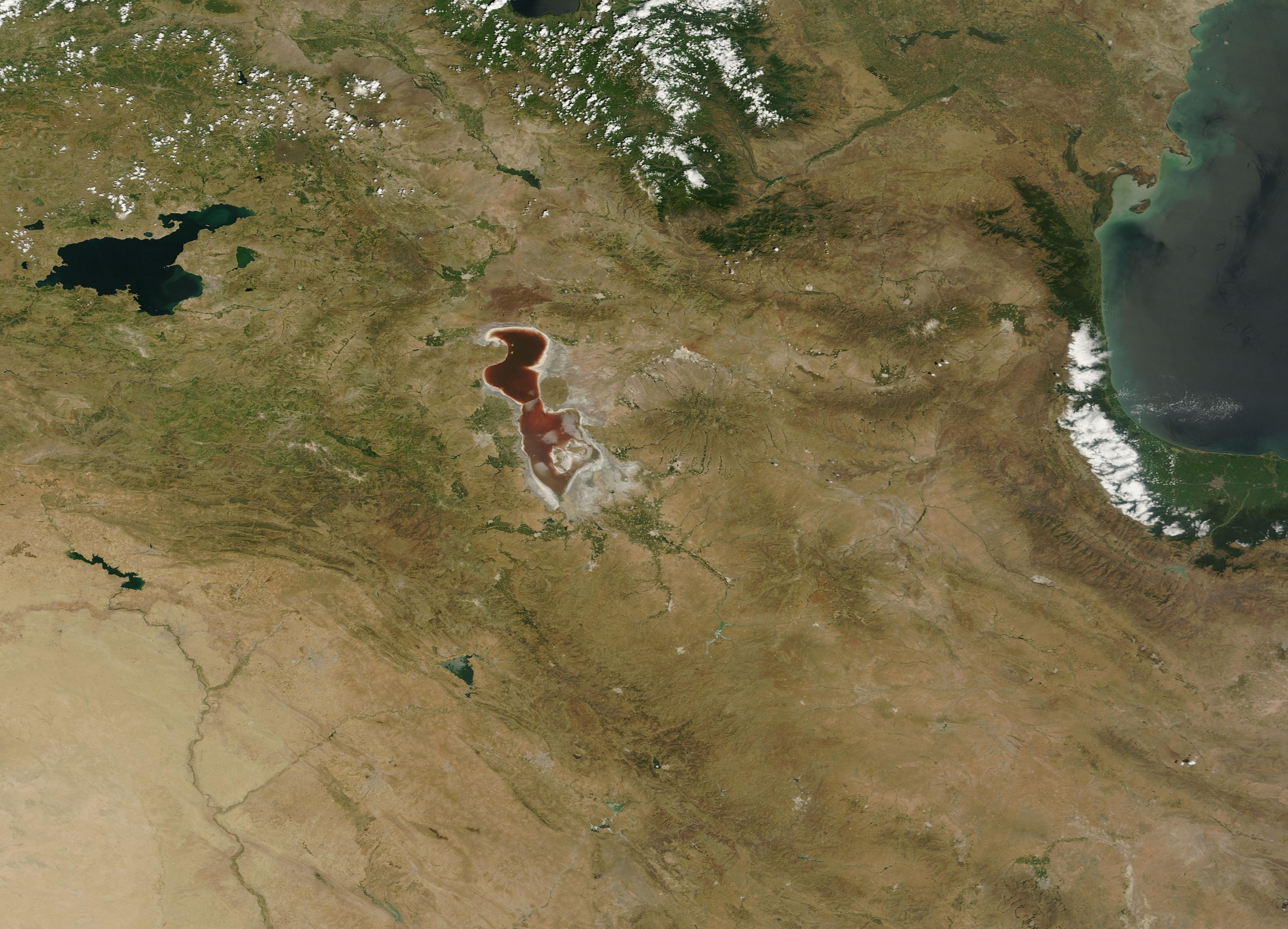
English: Lake Urmia, situated in northwestern Iran, is the world's second largest hypersaline salt lake and provides important water resources for the generally arid region. Despite its importance - or maybe because of it - the Lake has been steadily shrinking. Both a warming climate and increased water usages have been implicated as factors.
Also called Orumiyeh or Orumieh, the lake is fed by roughly 60 rivers and streams, some permanent and some ephemeral. The inflowing water also brings minerals and salts. Because the lake lacks an outflow, water can only leave by evaporation. Salts do not evaporate so they accumulate as crusty, reflective mineral deposits on the lake shore, and can be seen from space as a white rim around the lake. Similarly, white layers on the tan, sandy soil marks areas that used to be covered by water. The Moderate Resolution Imaging Spectroradiometer (MODIS) aboard NASA's Terra satellite flew over Lake Urmia and acquired this striking true-color image on July 1, 2016. The waters of the very shallow lake appear rusty-red, surrounded by a bright white ring of salt. The dark tan circular feature on the northeast shore of the lake is the remnant of an ancient, inactive volcano. Gray pixels on the southwest side of the lake represent the man-made structures in the city of Urmia. Green areas between the city of Urmia and the red lake waters are agricultural fields. The waters of Lake Urmia have traditionally appeared blue or greenish, as typical of most lakes. However, reports of the water turning red began to surface fairly recently. A study published in the International Journal of Aquatic Science in 2011 reported that the red coloration was not due to a typical "red tide" (overgrowth of the most common phytoplankton in the lake) as many had speculated. Instead, the organisms responsible were a type of Halobacteriaceae, which are very specialized bacteria that thrive in extremely salty conditions. Called halophiles ("salt-loving"), they produce pink-red pigments (bacterioruberins). When found in abundance, the pigments from these bacteria can turn super-salty water pink or red. The presence of the red-pigmented halophiles marks an environment that has become extraordinarly saline. |
||
| Date | Taken on 1 July 2016 | ||
| Source |
|
||
| Author | Jeff Schmaltz, MODIS Land Rapid Response Team, NASA GSFC |
| This media is a product of the Terra mission Credit and attribution belongs to the mission team, if not already specified in the "author" row |
Licensing edit
.jpg&action=edit§ion=2)
| This file is in the public domain in the United States because it was solely created by NASA. NASA copyright policy states that "NASA material is not protected by copyright unless noted". (See Template:PD-USGov, NASA copyright policy page or JPL Image Use Policy.) | ||
 |
Warnings:
|
File history
Click on a date/time to view the file as it appeared at that time.
| Date/Time | Thumbnail | Dimensions | User | Comment | |
|---|---|---|---|---|---|
| current | 19:28, 15 February 2024 | | 3,620 × 2,612 (1.21 MB) | OptimusPrimeBot (talk | contribs) | #Spacemedia - Upload of http://modis.gsfc.nasa.gov/gallery/images/image07062016_250m.jpg via Commons:Spacemedia |
You cannot overwrite this file.
File usage on Commons
There are no pages that use this file.
.jpg&oldid=852069793)