File:Lake Urmia (MODIS 2019-07-15).jpg

Original file (2,056 × 1,541 pixels, file size: 948 KB, MIME type: image/jpeg)
Captions
Captions
Summary edit
.jpg&action=edit§ion=1)
| Description |
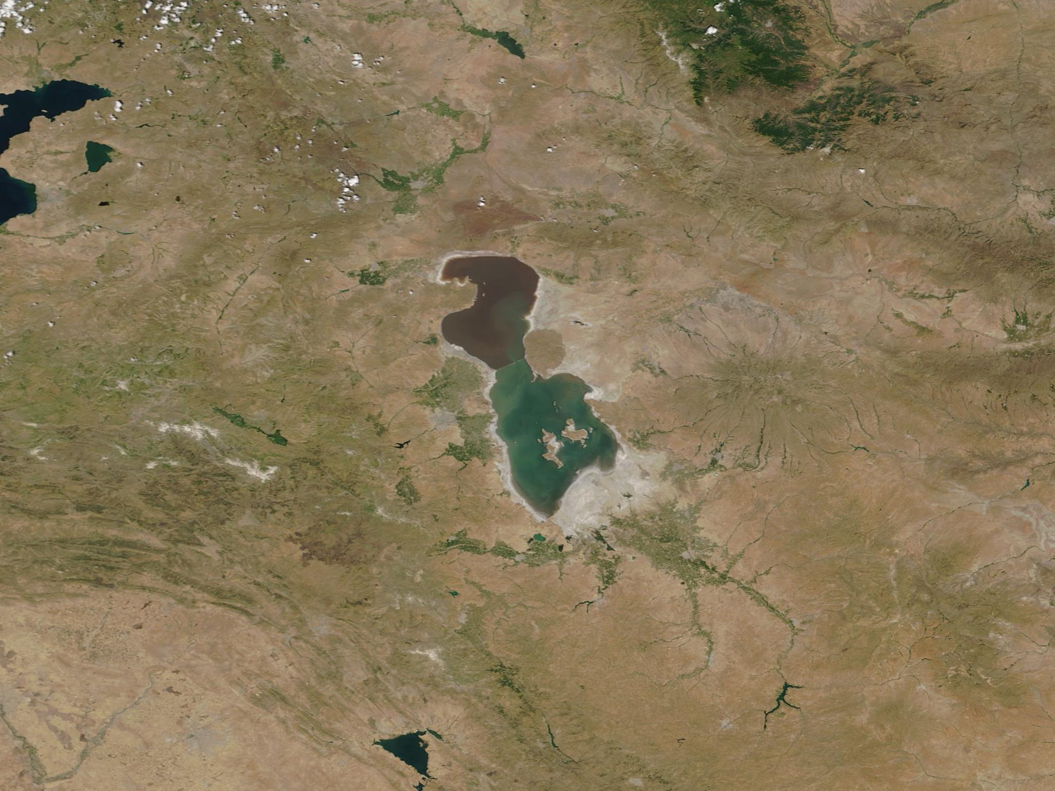
English: Located in arid northwestern Iran, Lake Urmia was once the second-largest saltwater lake in the Middle East and one of the largest hypersaline lakes in the world. Dotted by more than 100 rocky islands, Lake Urmia provided a rich habitat for a number of rare and endemic species, including Persian fallow deer and Armenia mouflon and a breeding ground for birds such as the flamingo. The unusual waters also provided a popular destination for locals and tourists alike.
Beginning in the 1970s, increasing temperatures, drought, and intensifying demands on water use caused massive shrinkage of the lake. In 1979 a causeway was built across the lake, separating it into two parts and leading to a mismatch of salinity between the north and south, with the north becoming more saline. And between 2005 and 2013, additional dams were placed on rivers feeding the lake, hastening the loss of water. In 1999, after almost three decades of shrinking, the volume of water was reported at 30 billion cubic meters. In 2013, that number was reduced to a half a billion cubic meters. In 1997, the surface area of Lake Urmia was 5,000 square kilometers, but by 2013 it had shrunk to a mere 500 square kilometers. Intense, torrential rains in late 2018 and 2019 have replenished the water levels of Lake Urmia. According to officials of Iran’s West Azerbaijan Regional Water Company in April, the size of Lake Urmia had expanded to about 3,000 square kilometers and its depth and increased by 62 cm (24.4 inches) due to the rains. The rains were the heaviest Iran had seen in at least 50 years. In mid-July, the lake still retained much of its new-found water. The Moderate Resolution Imaging Spectroradiometer (MODIS) on board NASA’s Terra satellite acquired a true-color image of Lake Urmia on July 12, 2019. The portion of the lake north of the causeway appears tinted red due to the type of phytoplankton (very small plant-like organisms) growing profusely in the highly-saline waters. |
||
| Date | Taken on 12 July 2019 | ||
| Source |
|
||
| Author | MODIS Land Rapid Response Team, NASA GSFC |
| This media is a product of the Terra mission Credit and attribution belongs to the mission team, if not already specified in the "author" row |
Licensing edit
.jpg&action=edit§ion=2)
| This file is in the public domain in the United States because it was solely created by NASA. NASA copyright policy states that "NASA material is not protected by copyright unless noted". (See Template:PD-USGov, NASA copyright policy page or JPL Image Use Policy.) | ||
 |
Warnings:
|
File history
Click on a date/time to view the file as it appeared at that time.
| Date/Time | Thumbnail | Dimensions | User | Comment | |
|---|---|---|---|---|---|
| current | 03:12, 17 February 2024 | | 2,056 × 1,541 (948 KB) | OptimusPrimeBot (talk | contribs) | #Spacemedia - Upload of http://modis.gsfc.nasa.gov/gallery/images/image07152019_250m.jpg via Commons:Spacemedia |
You cannot overwrite this file.
File usage on Commons
There are no pages that use this file.
.jpg&oldid=852766376)