File:Lakes-Washington-Oregon-9.GIF

Size of this preview: 800 × 600 pixels. Other resolutions: 320 × 240 pixels | 640 × 480 pixels | 960 × 720 pixels.
Original file (960 × 720 pixels, file size: 319 KB, MIME type: image/gif)
Captions
Captions
Add a one-line explanation of what this file represents
Summary
edit
| Description |
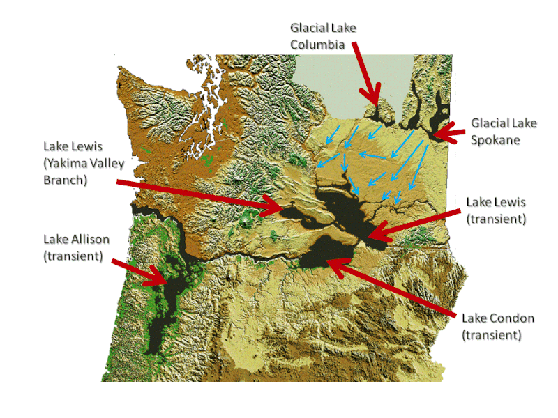
English: Shows proglacial lakes in the U.S.A. Pacific Northwest states of w:Washingon and w:Oregon. Addition of work identifying locations of lakes based upon several internet sources which will be referenced in article in which figures are used. |
| Date | |
| Source |
Modification of USGS Federal Government currently on commons titled File:Digital-elevation-map-washington.gif and File:Oregon_DEM_relief_map.gif Original Washington figure here and original Oregon figure here. |
| Author | Williamborg (talk) 00:23, 9 September 2009 (UTC) |
Licensing
edit
| I, the copyright holder of this work, release this work into the public domain. This applies worldwide. In some countries this may not be legally possible; if so: I grant anyone the right to use this work for any purpose, without any conditions, unless such conditions are required by law. |
File history
Click on a date/time to view the file as it appeared at that time.
| Date/Time | Thumbnail | Dimensions | User | Comment | |
|---|---|---|---|---|---|
| current | 00:23, 9 September 2009 | | 960 × 720 (319 KB) | Williamborg (talk | contribs) | {{Information |Description={{en|1=Shows proglacial lakes in the U.S.A. Pacific Northwest states of w:Washingon and w:Oregon. Addition of work identifying locations of lakes based upon several internet sources which will be referenced in article i |
You cannot overwrite this file.
File usage on Commons
The following page uses this file:
File usage on other wikis
The following other wikis use this file:
- Usage on de.wikipedia.org
- Usage on en.wikipedia.org
- Usage on fr.wikipedia.org
- Usage on www.wikidata.org