File:Laurencetown - geograph-3700750-by-Albert-Bridge.jpg
No higher resolution available.
Laurencetown_-_geograph-3700750-by-Albert-Bridge.jpg (640 × 373 pixels, file size: 122 KB, MIME type: image/jpeg)
Captions
Captions
Add a one-line explanation of what this file represents
Summary edit
| Description |
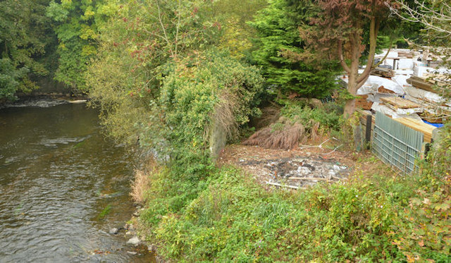
English: Course of old railway, Laurencetown The course of the Banbridge – Scarva line (closed 1955) - right) immediately after it had crossed the Point Road by this level crossing J1049 : Former Chapel Row level crossing, Laurencetown, is still clearly visible (lower right). The line continued towards Laurencetown station and Scarva by a bridge across the Bann (left). The bridge has gone but an abutment remains just above the river at upper left – see also J0949 : The River Bann at Laurencetown (2). The Google map is representational only. Subject positioned using the satellite photograph. |
| Date | |
| Source | From geograph.org.uk |
| Author | Albert Bridge |
| Permission (Reusing this file) |
Creative Commons Attribution Share-alike license 2.0 |
| Attribution (required by the license) | Albert Bridge / Course of old railway, Laurencetown / |
| Camera location | | View this and other nearby images on: OpenStreetMap |
|---|
_region:GB-NIR_heading:270.00&language=en)
| Object location | | View this and other nearby images on: OpenStreetMap |
|---|
_region:GB-NIR_heading:270.00&language=en)
Licensing edit

|
This image was taken from the Geograph project collection. See this photograph's page on the Geograph website for the photographer's contact details. The copyright on this image is owned by Albert Bridge and is licensed for reuse under the Creative Commons Attribution-ShareAlike 2.0 license.
|
This file is licensed under the Creative Commons Attribution-Share Alike 2.0 Generic license.
Attribution: Albert Bridge
- You are free:
- to share – to copy, distribute and transmit the work
- to remix – to adapt the work
- Under the following conditions:
- attribution – You must give appropriate credit, provide a link to the license, and indicate if changes were made. You may do so in any reasonable manner, but not in any way that suggests the licensor endorses you or your use.
- share alike – If you remix, transform, or build upon the material, you must distribute your contributions under the same or compatible license as the original.
File history
Click on a date/time to view the file as it appeared at that time.
| Date/Time | Thumbnail | Dimensions | User | Comment | |
|---|---|---|---|---|---|
| current | 19:45, 11 December 2020 | | 640 × 373 (122 KB) | Lamberhurst (talk | contribs) | == {{int:filedesc}} == {{Information |Description={{en|1=<b>Course of old railway, Laurencetown</b><br>The course of the Banbridge – Scarva line (closed 1955) - right) immediately after it had crossed the Point Road by this level crossing J1049 : Former Chapel Row level crossing, Laurencetown, is still clearly visible (lower right). The line continued towards Laurencetown station and Scarva by a bridge across the Bann (left). The... |
You cannot overwrite this file.
File usage on Commons
The following page uses this file: