File:Le village de Koerich (Duché de Luxembourg) sur la carte de Ferraris ou carte des Pays-Bas autrichiens (établie entre 1770 et 1778).jpg
No higher resolution available.
Le_village_de_Koerich_(Duché_de_Luxembourg)_sur_la_carte_de_Ferraris_ou_carte_des_Pays-Bas_autrichiens_(établie_entre_1770_et_1778).jpg (638 × 412 pixels, file size: 143 KB, MIME type: image/jpeg)
Captions
Captions
Add a one-line explanation of what this file represents
Summary
edit_sur_la_carte_de_Ferraris_ou_carte_des_Pays-Bas_autrichiens_(%C3%A9tablie_entre_1770_et_1778).jpg&action=edit§ion=1)
| Description |
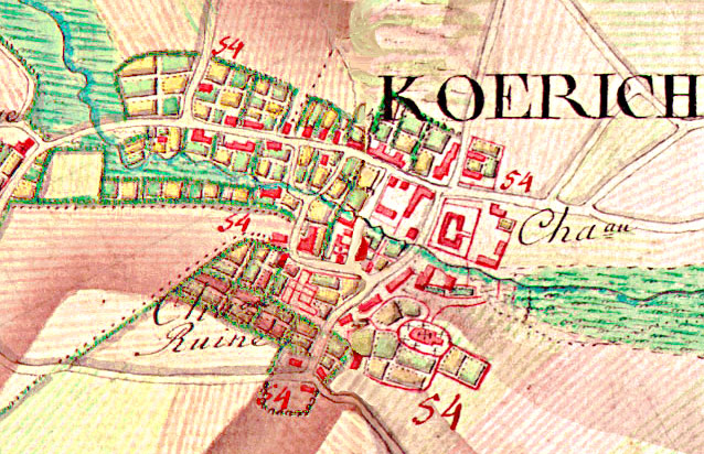
Lëtzebuergesch: D'Duerf Käerch op der de Ferrariskaart (géint 1775). Den Extrait weist d'Giewelerbaach a wou déi zwee Schlässer stoungen: am Osten d'Gréiweschlass an am Westen d'Ruine vum Fockeschlass. D'Kierch ass südlech an der Mëtt dertëscht. |
| Date | |
| Source | http://www.ksf.lu/index.php/de/gemeinde-koerich-und-das-tal-der-sieben-schloesser/fockeschlass |
| Author | "La carte de Ferraris ou carte des Pays-Bas autrichiens est une carte historique établie entre 1770 et 1778 par le comte Joseph de Ferraris, directeur de l'école de mathématique du corps d'artillerie des Pays-Bas, sur commande du gouverneur Charles de Lorraine. Il s'agit de la première cartographie systématique et à grande échelle, aussi bien en « Belgique » que dans toute l'Europe occidentale." (https://fr.wikipedia.org/wiki/Carte_de_Ferraris) |
| Camera location | | View this and other nearby images on: OpenStreetMap |
|---|
_sur_la_carte_de_Ferraris_ou_carte_des_Pays-Bas_autrichiens_(%C3%A9tablie_entre_1770_et_1778).jpg¶ms=049.668861_N_0005.945583_E_globe:Earth_type:camera__&language=en)
Illustration pour un article sur l'histoire locale
Licensing
edit_sur_la_carte_de_Ferraris_ou_carte_des_Pays-Bas_autrichiens_(%C3%A9tablie_entre_1770_et_1778).jpg&action=edit§ion=2)
| This file is made available under the Creative Commons CC0 1.0 Universal Public Domain Dedication. | |
| The person who associated a work with this deed has dedicated the work to the public domain by waiving all of their rights to the work worldwide under copyright law, including all related and neighboring rights, to the extent allowed by law. You can copy, modify, distribute and perform the work, even for commercial purposes, all without asking permission.
|
File history
Click on a date/time to view the file as it appeared at that time.
| Date/Time | Thumbnail | Dimensions | User | Comment | |
|---|---|---|---|---|---|
| current | 07:19, 8 August 2020 | | 638 × 412 (143 KB) | Mischnachtreisr (talk | contribs) | Uploaded a work by "La carte de Ferraris ou carte des Pays-Bas autrichiens est une carte historique établie entre 1770 et 1778 par le comte Joseph de Ferraris, directeur de l'école de mathématique du corps d'artillerie des Pays-Bas, sur commande du gouverneur Charles de Lorraine. Il s'agit de la première cartographie systématique et à grande échelle, aussi bien en « Belgique » que dans toute l'Europe occidentale." (https://fr.wikipedia.org/wiki/Carte_de_Ferraris) from http://www.ksf.lu/index.... |
You cannot overwrite this file.
File usage on Commons
The following page uses this file:
File usage on other wikis
The following other wikis use this file:
- Usage on fr.wikipedia.org
- Usage on lb.wikipedia.org
_sur_la_carte_de_Ferraris_ou_carte_des_Pays-Bas_autrichiens_(établie_entre_1770_et_1778).jpg&oldid=461084398)