File:Lezgin map.png

Size of this preview: 761 × 600 pixels. Other resolutions: 305 × 240 pixels | 609 × 480 pixels | 902 × 711 pixels.
Original file (902 × 711 pixels, file size: 40 KB, MIME type: image/png)
Captions
Captions
Add a one-line explanation of what this file represents
Summary edit
| Description |
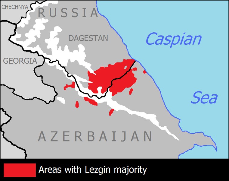
English: Map showing the distribution of Lezgin people in Dagestan (Russia) and Azerbaijan in 2003.
|
| Date | |
| Source | Own work |
| Author | Yerevanci |
Licensing edit
I, the copyright holder of this work, hereby publish it under the following license:
This file is licensed under the Creative Commons Attribution-Share Alike 3.0 Unported license.
- You are free:
- to share – to copy, distribute and transmit the work
- to remix – to adapt the work
- Under the following conditions:
- attribution – You must give appropriate credit, provide a link to the license, and indicate if changes were made. You may do so in any reasonable manner, but not in any way that suggests the licensor endorses you or your use.
- share alike – If you remix, transform, or build upon the material, you must distribute your contributions under the same or compatible license as the original.
File history
Click on a date/time to view the file as it appeared at that time.
| Date/Time | Thumbnail | Dimensions | User | Comment | |
|---|---|---|---|---|---|
| current | 20:11, 19 January 2021 | | 902 × 711 (40 KB) | Raa555 (talk | contribs) | Reverted to version as of 07:38, 27 September 2018 (UTC) |
| 14:22, 15 January 2021 |  | 1,219 × 790 (41 KB) | Golden (talk | contribs) | Reverted to version as of 20:55, 8 January 2021 (UTC) rv vandalism | |
| 02:38, 15 January 2021 |  | 774 × 915 (50 KB) | Raa555 (talk | contribs) | Reverted to version as of 13:47, 8 January 2021 (UTC) | |
| 20:55, 8 January 2021 |  | 1,219 × 790 (41 KB) | Golden (talk | contribs) | Reverted to version as of 08:13, 8 January 2021 (UTC) revert; stop editwarring and restoring an unsourced/POV version | |
| 13:47, 8 January 2021 |  | 774 × 915 (50 KB) | Raa555 (talk | contribs) | Reverted to version as of 21:50, 7 January 2021 (UTC) | |
| 08:13, 8 January 2021 |  | 1,219 × 790 (41 KB) | Golden (talk | contribs) | Reverted to version as of 18:08, 19 November 2020 (UTC) | |
| 21:50, 7 January 2021 |  | 774 × 915 (50 KB) | Raa555 (talk | contribs) | Reverted to version as of 16:08, 20 October 2017 (UTC) | |
| 18:08, 19 November 2020 |  | 1,219 × 790 (41 KB) | Golden (talk | contribs) | remade the whole map; used a modern source (old one was 1886-1890 source) | |
| 13:17, 4 September 2019 |  | 902 × 711 (40 KB) | Soul Train (talk | contribs) | Reverted to version as of 07:38, 27 September 2018 (UTC) | |
| 21:08, 11 January 2019 |  | 774 × 915 (50 KB) | Raa555 (talk | contribs) | Reverted to version as of 16:08, 20 October 2017 (UTC)vandalism |
You cannot overwrite this file.
File usage on Commons
There are no pages that use this file.
File usage on other wikis
The following other wikis use this file:
- Usage on da.wikipedia.org
- Usage on en.wikipedia.org
- Usage on fa.wikipedia.org
- Usage on gl.wikipedia.org
- Usage on hy.wikipedia.org
- Usage on ja.wikipedia.org
- Usage on ky.wikipedia.org
- Usage on ru.wikipedia.org
- Usage on sco.wikipedia.org