File:Linate Airport disaster map en.gif

Size of this preview: 360 × 599 pixels. Other resolutions: 144 × 240 pixels | 288 × 480 pixels | 462 × 768 pixels | 1,109 × 1,844 pixels.
Original file (1,109 × 1,844 pixels, file size: 31 KB, MIME type: image/gif)
Captions
Captions
Add a one-line explanation of what this file represents

|
This transport map image could be re-created using vector graphics as an SVG file. This has several advantages; see Commons:Media for cleanup for more information. If an SVG form of this image is available, please upload it and afterwards replace this template with
{{vector version available|new image name}}.
It is recommended to name the SVG file “Linate Airport disaster map en.svg”—then the template Vector version available (or Vva) does not need the new image name parameter. |
| Description |
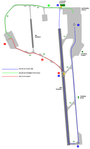
English: Map showing the routes of the aircraft involved at Linate Airport disaster at Linate Airport (LIN/LIML) in Milan, Italy on 2001-10-08.
Suomi: Kartta Milanon lento-onnettomuuden onnettomuuskoneiden reiteistä Linaten lentoasemalla (LIN/LIML), Milanossa, Italiassa 8.10.2001.
Italiano: Mappa delle rotte dei velivoli coinvolti nel disastro aereo di Linate, all'aeroporto di Linate (LIN/LIML) in Italia, a Milano, l'8 ottobre 2001. |
| Date |
(original version in Italian) 2006-10-17 (translated into English) |
| Source | Original version: Immagine:Disastro Linate.GIF at it.wikipedia (later on transferred to Commons as Image:Linate Airport disaster map it.gif) |
| Author |
Pikappa at Italian Wikipedia (original author of the Italian version) Attilios at en.wikipedia (translated into English) |
| Other versions |
Italiano: Image:Linate Airport disaster map it.gif |
| This file is licensed under the Creative Commons Attribution-Share Alike 3.0 Unported license. Subject to disclaimers. | ||
| ||
| This licensing tag was added to this file as part of the GFDL licensing update. |

|
Permission is granted to copy, distribute and/or modify this document under the terms of the GNU Free Documentation License, Version 1.2 or any later version published by the Free Software Foundation; with no Invariant Sections, no Front-Cover Texts, and no Back-Cover Texts. A copy of the license is included in the section entitled GNU Free Documentation License. Subject to disclaimers. |
Original upload log edit
Transferred from it.wikipedia to Commons. to en.wikipedia and translated by Attilios at en.wikipedia
Transferred from en.wikipedia to Commons by Apalsola using CommonsHelper.
The original description page was here. All following user names refer to en.wikipedia.
- 2006-10-17 11:54 Attilios 1109×1844×8 (31785 bytes) modification of image with same name in it.wikipedia {{GFDL}}
File history
Click on a date/time to view the file as it appeared at that time.
| Date/Time | Thumbnail | Dimensions | User | Comment | |
|---|---|---|---|---|---|
| current | 12:05, 30 July 2008 | | 1,109 × 1,844 (31 KB) | Apalsola (talk | contribs) | {{Information |Description= {{en|1=Map showing the routes of the aircraft involved at Linate Airport disaster at Linate Airport (LIN/LIML) in Milan, Italy on 2001-10-08.}} {{fi|1=Kartta Milanon lento-onnettomuuden o |
You cannot overwrite this file.
File usage on Commons
The following 2 pages use this file:
File usage on other wikis
The following other wikis use this file:
- Usage on ar.wikipedia.org
- Usage on da.wikipedia.org
- Usage on de.wikipedia.org
- Usage on en.wikipedia.org
- Usage on es.wikipedia.org
- Usage on et.wikipedia.org
- Usage on fi.wikipedia.org
- Usage on fr.wikipedia.org
- Usage on he.wikipedia.org
- Usage on it.wikipedia.org
- Usage on ja.wikipedia.org
- Usage on nl.wikipedia.org
- Usage on no.wikipedia.org
- Usage on pt.wikipedia.org
- Usage on ru.wikipedia.org
- Usage on www.wikidata.org
- Usage on zh.wikipedia.org