File:Line of rebel works, Smith's Island, N.C. Evacuated January 16th, 1865. Taken possession of by naval and military forces January 17th, 1865. Surveyed by J. S. Bradford, U.S. Coast Survey, A.D.C. to LOC 99447482.jpg

Size of this preview: 483 × 600 pixels. Other resolutions: 193 × 240 pixels | 386 × 480 pixels | 618 × 768 pixels | 824 × 1,024 pixels | 1,649 × 2,048 pixels | 2,748 × 3,413 pixels.
Original file (2,748 × 3,413 pixels, file size: 979 KB, MIME type: image/jpeg)
Captions
Captions
Add a one-line explanation of what this file represents
Summary edit
| Description |
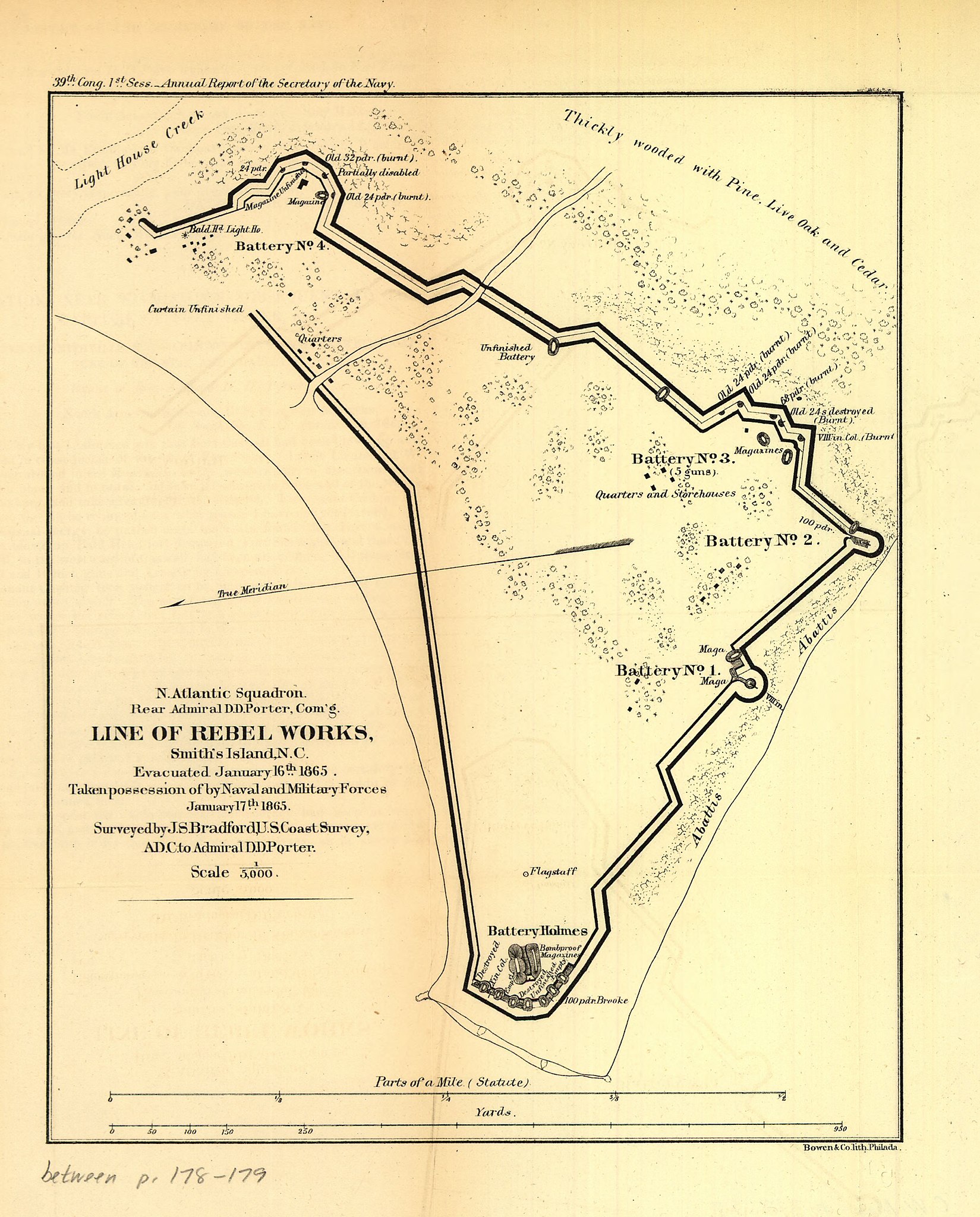
English: Scale 1:5000. LC Civil War Maps (2nd ed.), 317.37 From Message of the President of the United States, and accompanying documents, to the two houses of Congress, at the commencement of the first session of the thirty-ninth Congress.-Report of the Secretary of the Navy (Washington, Government Printing Office, 1865). fol. p. 178. At head of title: N. Atlantic Squadron. Rear Admiral D. D. Porter, Com'g. Printed in upper left margin: 39th Cong. 1st Sess.-Annual Report of the Secretary of the Navy. Description derived from published bibliography. Available also through the Library of Congress web site as raster image. |
||
| Title | Line of rebel works, Smith's Island, N.C. Evacuated January 16th, 1865. Taken possession of by naval and military forces January 17th, 1865. Surveyed by J. S. Bradford, U.S. Coast Survey, A.D.C. to Admiral D. D. Porter | ||
| Shelf ID | G3902.S6 1865 .B7 | ||
| Date | |||
| Source | https://www.loc.gov/item/99447482/ | ||
| Author | Bradford, J. S. | ||
| Permission (Reusing this file) |
|
||
| Other versions |
|
||
| Location | United States · Smith Island · North Carolina | ||
| Part of | Military Battles And Campaigns · American Memory · Civil War Maps · Catalog · Geography And Map Division | ||
| Subject | United States · Maps · Smith Island (N.C.) · Smith Island · North Carolina |


Licensing edit
|
This is a faithful photographic reproduction of a two-dimensional, public domain work of art. The work of art itself is in the public domain for the following reason:
The official position taken by the Wikimedia Foundation is that "faithful reproductions of two-dimensional public domain works of art are public domain".
This photographic reproduction is therefore also considered to be in the public domain in the United States. In other jurisdictions, re-use of this content may be restricted; see Reuse of PD-Art photographs for details. | ||||
File history
Click on a date/time to view the file as it appeared at that time.
| Date/Time | Thumbnail | Dimensions | User | Comment | |
|---|---|---|---|---|---|
| current | 11:39, 5 June 2018 | | 2,748 × 3,413 (979 KB) | Fæ (talk | contribs) | LOC Maps https://www.loc.gov/item/99447482/ #20765 |
You cannot overwrite this file.
File usage on Commons
The following page uses this file: