File:Linke Nebenflüsse der Sill.png

Size of this preview: 719 × 600 pixels. Other resolutions: 288 × 240 pixels | 576 × 480 pixels | 844 × 704 pixels.
Original file (844 × 704 pixels, file size: 1.03 MB, MIME type: image/png)
Captions
Captions
Add a one-line explanation of what this file represents
Summary edit
| Description |
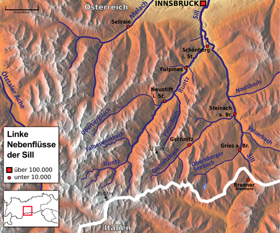
Deutsch: Linke Nebenflüsse der Sill (Ruetz, Gschnitzbach Obernberger Seebach) mit Melach, Navisbach und Valserbach
English: Left tributaries of the Sill river (Ruetz, Gschnitzbach, Obernberger Seebach) with Melach river, Navisbach and Valserbach |
| Date | |
| Source |
Own work Datenquelle: basemap.at |
| Author | Clever Clog, basemap.at, Hans Braxmeier, NordNordWest |
Licensing edit
This file is licensed under the Creative Commons Attribution-Share Alike 3.0 Unported license.
- You are free:
- to share – to copy, distribute and transmit the work
- to remix – to adapt the work
- Under the following conditions:
- attribution – You must give appropriate credit, provide a link to the license, and indicate if changes were made. You may do so in any reasonable manner, but not in any way that suggests the licensor endorses you or your use.
- share alike – If you remix, transform, or build upon the material, you must distribute your contributions under the same or compatible license as the original.
File history
Click on a date/time to view the file as it appeared at that time.
| Date/Time | Thumbnail | Dimensions | User | Comment | |
|---|---|---|---|---|---|
| current | 13:05, 4 May 2016 | | 844 × 704 (1.03 MB) | Clever Clog (talk | contribs) | Korrektur |
| 12:46, 4 May 2016 |  | 844 × 707 (1.36 MB) | Clever Clog (talk | contribs) | Minikarte | |
| 11:05, 4 May 2016 |  | 808 × 742 (1.3 MB) | Clever Clog (talk | contribs) | User created page with UploadWizard |
You cannot overwrite this file.
File usage on Commons
The following page uses this file:
File usage on other wikis
The following other wikis use this file:
- Usage on de.wikipedia.org
- Usage on en.wikipedia.org