File:Livland 1260.svg

Size of this PNG preview of this SVG file: 554 × 600 pixels. Other resolutions: 222 × 240 pixels | 443 × 480 pixels | 709 × 768 pixels | 946 × 1,024 pixels | 1,891 × 2,048 pixels | 955 × 1,034 pixels.
Original file (SVG file, nominally 955 × 1,034 pixels, file size: 790 KB)
Captions
Captions
Add a one-line explanation of what this file represents
Summary edit
| Description |
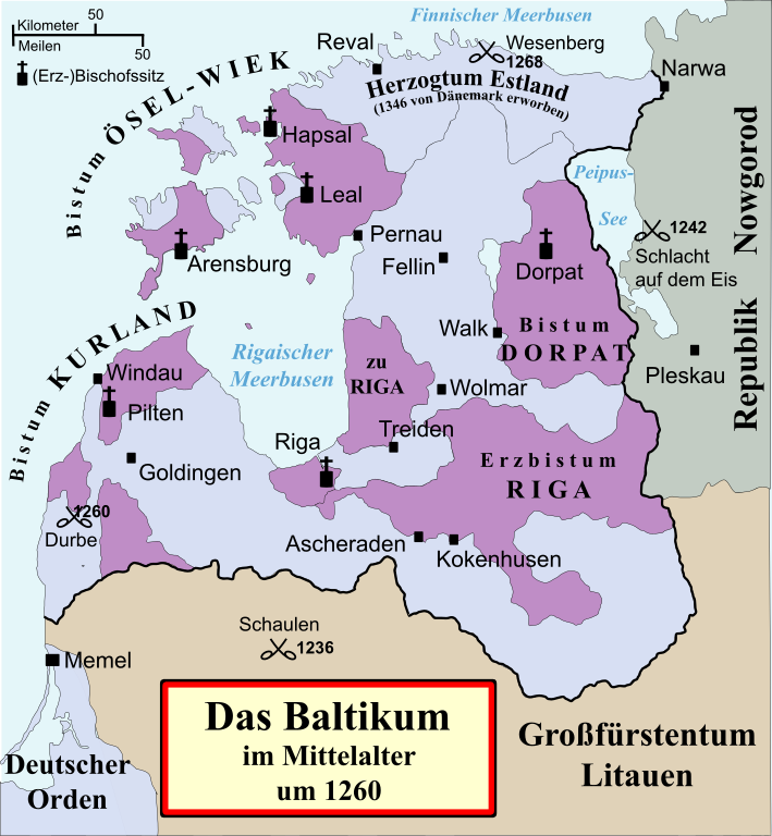
Deutsch: Politische Karte von Livland im Mittelalter, etwa 1260.
Besitz des Schwertbrüderordens bzw. Deutschen Ordens (in Preußen) Geistlicher Besitz English: Political map of the Medieval Livonia, circa 1260, along with surrounding areas:
Possessions of the Sword Brothers (in Livonia) and the Teutonic Order (in Prussia) Ecclesiastical possessions |
||||||||
| Date | |||||||||
| Source |
Own work, using
|
||||||||
| Author | Originally created by MapMaster, commissioned by Attilios, translated by NordNordWest, modified by Furfur | ||||||||
| Permission (Reusing this file) |
I, the copyright holder of this work, hereby publish it under the following license:
|
||||||||
| Other versions |
|
||||||||
| SVG development |

File history
Click on a date/time to view the file as it appeared at that time.
| Date/Time | Thumbnail | Dimensions | User | Comment | |
|---|---|---|---|---|---|
| current | 17:22, 30 December 2013 | | 955 × 1,034 (790 KB) | Furfur (talk | contribs) | Pardon, nochmal |
| 17:19, 30 December 2013 |  | 955 × 1,034 (790 KB) | Furfur (talk | contribs) | Datum der Schlacht von Schaulen korrigiert | |
| 13:05, 23 April 2013 |  | 955 × 1,034 (791 KB) | Furfur (talk | contribs) | die bisherige Farbgebung gefällt mir irgendwie noch nicht - Versuch einer Verbesserung | |
| 09:34, 10 December 2012 |  | 955 × 1,034 (791 KB) | Furfur (talk | contribs) | Farbkorrektur,Walk ergänzt | |
| 17:57, 8 December 2012 |  | 955 × 1,034 (402 KB) | Furfur (talk | contribs) | typo: Piltene -> Pilten | |
| 17:50, 8 December 2012 |  | 955 × 1,034 (401 KB) | Furfur (talk | contribs) | dezentere Farbgebung, kleinere Koeekturen (z. B. Estland schon seit 1346 formell im Besitz des Ordens), Schriften vektorisiert -> einfachere Übersetzung möglich | |
| 10:08, 1 September 2009 |  | 955 × 1,034 (1,002 KB) | NordNordWest (talk | contribs) | {{int:filedesc}} {{Information |Description= {{de|Politische Karte von Livland im Mittelalter, etwa 1260.}} {{en|Political map of the Medieval Livonia, circa 1260, along with surrounding areas.}} |Source={{Own}}, using * {{cite book|first=Stephen|last=Tu |
You cannot overwrite this file.
File usage on Commons
There are no pages that use this file.
File usage on other wikis
The following other wikis use this file:
- Usage on af.wikipedia.org
- Usage on de.wikipedia.org
- 1242
- 1260
- Lettland
- Estland
- Baltikum
- Liven
- Livland
- Deutsch-Balten
- Schwertbrüderorden
- Schlacht auf dem Peipussee
- Liste der Erzbischöfe von Riga
- Bistum Kurland
- Bistum Ösel-Wiek
- Schlacht an der Durbe
- Schlacht von Schaulen (1236)
- Livländische Konföderation
- Litauerkriege des Deutschen Ordens
- Landmeister in Livland
- Wikipedia:Kartenwerkstatt/Archiv/2009-09
- Schlacht bei Wesenberg (1268)
- Schlacht von Aizkraukle
- Liste der Backsteinbauwerke der Gotik in Estland und Lettland
- Usage on eo.wikipedia.org
- Usage on et.wikipedia.org
- Usage on frr.wikipedia.org
- Usage on fr.wikipedia.org
- Usage on kk.wikipedia.org
- Usage on lv.wikipedia.org
- Usage on ro.wikipedia.org
- Usage on sl.wikipedia.org