File:Location of Liuzhou Prefecture within Guangxi (China).png

Size of this preview: 754 × 600 pixels. Other resolutions: 302 × 240 pixels | 604 × 480 pixels | 880 × 700 pixels.
Original file (880 × 700 pixels, file size: 86 KB, MIME type: image/png)
Captions
Captions
Add a one-line explanation of what this file represents

|
This locator map image could be re-created using vector graphics as an SVG file. This has several advantages; see Commons:Media for cleanup for more information. If an SVG form of this image is available, please upload it and afterwards replace this template with
{{vector version available|new image name}}.
It is recommended to name the SVG file “Location of Liuzhou Prefecture within Guangxi (China).svg”—then the template Vector version available (or Vva) does not need the new image name parameter. |
Summary edit
.png&action=edit§ion=1)
| Description |
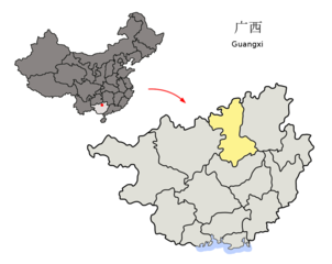
Location of Liuzhou Prefecture (yellow) within Guangxi Autonomous Region of China Map drawn in november 2007 using various sources, mainly : |
| Date | |
| Source | Own work |
| Author | Croquant |
Licensing edit
.png&action=edit§ion=2)
I, the copyright holder of this work, hereby publish it under the following license:
This file is licensed under the Creative Commons Attribution 3.0 Unported license.
- You are free:
- to share – to copy, distribute and transmit the work
- to remix – to adapt the work
- Under the following conditions:
- attribution – You must give appropriate credit, provide a link to the license, and indicate if changes were made. You may do so in any reasonable manner, but not in any way that suggests the licensor endorses you or your use.
File history
Click on a date/time to view the file as it appeared at that time.
| Date/Time | Thumbnail | Dimensions | User | Comment | |
|---|---|---|---|---|---|
| current | 14:11, 1 December 2007 | | 880 × 700 (86 KB) | Croquant (talk | contribs) | coastline |
| 10:09, 17 November 2007 |  | 880 × 700 (85 KB) | Croquant (talk | contribs) | == Summary == {{Information |Description=Location of Liuzhou Prefecture (yellow) within Guangxi Autonomous Region of China Map drawn in november 2007 using various sources, mainly : * [http://sedac.ciesin.org/china/admin/bnd90/t4590.html Guangxi Autonomo |
You cannot overwrite this file.
File usage on Commons
The following page uses this file:
File usage on other wikis
The following other wikis use this file:
- Usage on da.wikipedia.org
- Usage on en.wikipedia.org
- Usage on fi.wikipedia.org
- Usage on fr.wikipedia.org
- Usage on hak.wikipedia.org
- Usage on id.wikipedia.org
- Usage on it.wikipedia.org
- Usage on ja.wikipedia.org
- Usage on kk.wikipedia.org
- Usage on ko.wikipedia.org
- Usage on nl.wikipedia.org
- Usage on nn.wikipedia.org
- Usage on no.wikipedia.org
- Usage on pl.wikipedia.org
- Usage on sv.wikipedia.org
- Usage on ug.wikipedia.org
- Usage on vi.wikipedia.org
- Usage on za.wikipedia.org
- Usage on zh.wikipedia.org
.png&oldid=496662434)