File:Loesertalkopf Gipfelpanorama.jpg

Size of this preview: 798 × 81 pixels. Other resolutions: 320 × 32 pixels | 640 × 65 pixels | 1,024 × 104 pixels | 1,280 × 130 pixels | 10,304 × 1,046 pixels.
Original file (10,304 × 1,046 pixels, file size: 2.89 MB, MIME type: image/jpeg)
Captions
Captions
Add a one-line explanation of what this file represents
Summary edit
| Description |
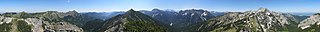
Deutsch: Gipfelpanorama vom Lösertalkopf in den Ammergauer Alpen. Anmerkungen im ↑Bild↑ mit Mauszeiger, rechts vom Forggensee nahe des Tegelbergs (auch die Tannheimer Berge verdeckt von Geiselstein und Hochplatte) über die höheren Berggipfel im Ammergebirge (mit der Zugspitze von fern) über das Tal der Linder bis zu den Gipfeln am Nordrand der Alpen. Gute Fernsicht auch zu noch weiter entfernteren Gipfeln im Süden und Osten. |
| Date | |
| Source | Own work |
| Author | Jensibua |
| Camera location | | View this and other nearby images on: OpenStreetMap |
|---|
Licensing edit
I, the copyright holder of this work, hereby publish it under the following license:
| This file is made available under the Creative Commons CC0 1.0 Universal Public Domain Dedication. | |
| The person who associated a work with this deed has dedicated the work to the public domain by waiving all of their rights to the work worldwide under copyright law, including all related and neighboring rights, to the extent allowed by law. You can copy, modify, distribute and perform the work, even for commercial purposes, all without asking permission.
|
| Annotations | This image is annotated: View the annotations at Commons |


File history
Click on a date/time to view the file as it appeared at that time.
| Date/Time | Thumbnail | Dimensions | User | Comment | |
|---|---|---|---|---|---|
| current | 23:50, 22 July 2012 | 10,304 × 1,046 (2.89 MB) | Jensibua (talk | contribs) | Pano verbessert, Übergänge beseitigt, gerade geschnitte | |
| 11:45, 17 June 2012 | 15,915 × 1,340 (4.31 MB) | Jensibua (talk | contribs) | {{Information |Description ={{de|1=Gipfelpanorama vom Löstertalkopf in den Ammergauer Alpen}} |Source ={{own}} |Author =Jensibua |Date =2012-06-16 |Permission = |other_versions = }} {{Location|47|33|2... |
You cannot overwrite this file.
File usage on Commons
The following 2 pages use this file:
File usage on other wikis
The following other wikis use this file:
- Usage on de.wikipedia.org