File:Looking SW at northern corner from trail - former Constitution Avenue NW terminus - 2013-05-02.jpg

Original file (2,000 × 1,157 pixels, file size: 1.53 MB, MIME type: image/jpeg)
Captions
Captions
Summary edit
| Description |
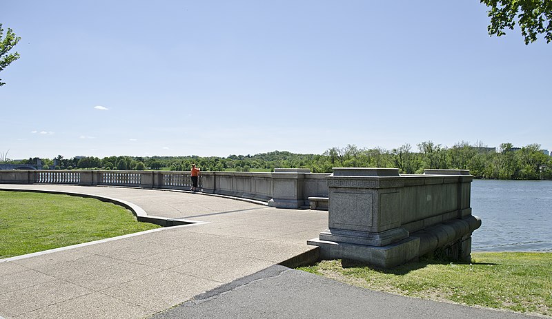
English: Looking southwest at the former terminus of Constitution Avenue NW in Washington, D.C., in the United States. The small traffic circle and granite terrace with balustrade form the terminus. The Potomac River and Virginia can be see in the background.
Constitution Avenue NW existed only between 3rd and 15th Streets NW from the city's inception in 1791 to 1871. Between 1871 and 1873, the city covered over the Tiber Creek estuary and built the street on top of it west to Virginia Avenue NW. Between 1881 and 1890, the city dredged the Potomac River and reclaimed the land that now constitutes West Potomac Park (for use as a levee). Constitution Avenue NW was then extended through the park to 23rd Street NW. When Arlington Memorial Bridge was authorized for construction in 1926, Congress ordered that "B Street" be extended to the Potomac River and widened into a ceremonial gateway for the city. In 1931, Congress changed the name of "B Street" to Constitution Avenue. A granite terrace and small traffic circle was constructed on the shores of the Potomac to form the western terminus of the street. In the 1950s, Congress authorized construction of the Theodore Roosevelt Memorial Bridge, and ordered that the bridge connect with Interestate-66 (then being built from the east toward the city). Constitution Avenue NW was torn up and the area restored to parkland west of 23rd Street NW. Raised on-ramps and off-ramps were built through the area to connect the avenue to the bridge. The terrace and traffic circle were not destroyed, however. In 1901, the Senate Parks Commission produced a master plan (the "McMillan Plan") to beautify the National Mall area in Washington, D.C. Among its requirements was that sidewalks on the Mall be lined with double-rows of American elms and beeches. Although the sidewalks were removed when Constitution Avenue was torn up in the 1950s, some of the double-rows of trees survived. |
| Date | |
| Source | https://www.flickr.com/photos/23165290@N00/8705881434/ |
| Author | Tim Evanson |
Licensing edit
- You are free:
- to share – to copy, distribute and transmit the work
- to remix – to adapt the work
- Under the following conditions:
- attribution – You must give appropriate credit, provide a link to the license, and indicate if changes were made. You may do so in any reasonable manner, but not in any way that suggests the licensor endorses you or your use.
- share alike – If you remix, transform, or build upon the material, you must distribute your contributions under the same or compatible license as the original.
| This image was originally posted to Flickr by dctim1 at https://www.flickr.com/photos/23165290@N00/8705881434. It was reviewed on 4 May 2013 by FlickreviewR and was confirmed to be licensed under the terms of the cc-by-sa-2.0. |
File history
Click on a date/time to view the file as it appeared at that time.
| Date/Time | Thumbnail | Dimensions | User | Comment | |
|---|---|---|---|---|---|
| current | 23:33, 4 May 2013 | | 2,000 × 1,157 (1.53 MB) | Tim1965 (talk | contribs) | {{Information |Description ={{en|1=Looking southwest at the former terminus of Constitution Avenue NW in Washington, D.C., in the United States. The small traffic circle and granite terrace with balustrade form the terminus. The Potomac River and ... |
You cannot overwrite this file.
File usage on Commons
There are no pages that use this file.