File:Luchtopname van het Noordereiland met de Maaskade, Prins Hendrikkade, Koningshaven, Nieuwe Maas, Willemsbrug, Willemsspoorbrug, Boompjes en Scheepmakershaven 1921.jpg

Size of this preview: 749 × 599 pixels. Other resolutions: 300 × 240 pixels | 600 × 480 pixels | 960 × 768 pixels | 1,280 × 1,024 pixels | 2,559 × 2,048 pixels | 2,600 × 2,081 pixels.
Original file (2,600 × 2,081 pixels, file size: 2.64 MB, MIME type: image/jpeg)
Captions
Captions
Add a one-line explanation of what this file represents
Summary edit
| Description |
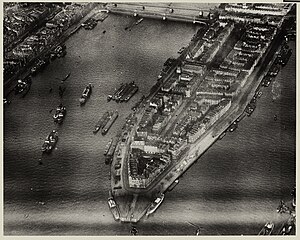
English: Aerial view of the Noordereiland, at the height of the Prinsenhoofd and the Prins Hendrikkade, on the right, near the Koningshaven. Further on on the left the Willemsbrug and the railway bridge over the Nieuwe Maas. On the far left the Boompjes and the Scheepmakershaven. From the southwest. Year: 1921.
Nederlands: Luchtopname van het Noordereiland, ter hoogte van het Prinsenhoofd en de Prins Hendrikkade, rechts, bij de Koningshaven. Verderop links de Willemsbrug en de spoorbrug over de Nieuwe Maas. Uiterst links de Boompjes en de Scheepmakershaven. Uit het zuidwesten. Jaar: 1921. |
| Date | |
| Source | Stadsarchief Rotterdam |
| Author | KLM Aerocarto |
Licensing edit
| This file is made available under the Creative Commons CC0 1.0 Universal Public Domain Dedication. | |
| The person who associated a work with this deed has dedicated the work to the public domain by waiving all of their rights to the work worldwide under copyright law, including all related and neighboring rights, to the extent allowed by law. You can copy, modify, distribute and perform the work, even for commercial purposes, all without asking permission.
|
File history
Click on a date/time to view the file as it appeared at that time.
| Date/Time | Thumbnail | Dimensions | User | Comment | |
|---|---|---|---|---|---|
| current | 20:38, 7 June 2023 | | 2,600 × 2,081 (2.64 MB) | MatteoNL97 (talk | contribs) | Uploaded a work by KLM Aerocarto from [https://hdl.handle.net/21.12133/0720CF94F42B49E1B9E08E50EA7BB87B Stadsarchief Rotterdam] with UploadWizard |
You cannot overwrite this file.
File usage on Commons
There are no pages that use this file.