File:Luwian Language de.svg

Size of this PNG preview of this SVG file: 638 × 599 pixels. Other resolutions: 256 × 240 pixels | 511 × 480 pixels | 818 × 768 pixels | 1,090 × 1,024 pixels | 2,181 × 2,048 pixels | 790 × 742 pixels.
Original file (SVG file, nominally 790 × 742 pixels, file size: 308 KB)
Captions
Captions
Add a one-line explanation of what this file represents
| Description |
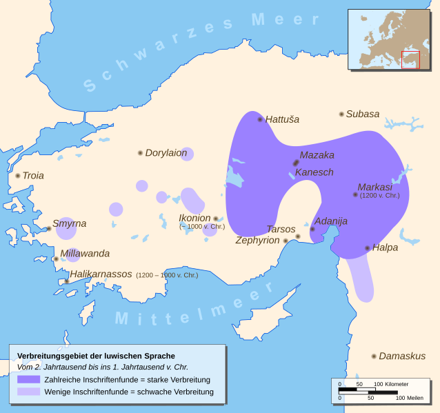
English: Map of a part of Eastern Europe/Asia with spreading of the Luwian Language
Deutsch: Karte mit Teilen Ost-Europas/Asiens mit dem Verbreitungsgebiet der luwischen Sprache |
| Date | |
| Source |
Drawn by myself, based on different source maps: Continental outlines (by San Jose), Luwian Language spreading (by Enlil2), Cities, Locator map Enlil2 extracted the data from the book “The Luwians” (H. Craig Melchert, Brill 2003) This W3C-unspecified vector image was created with Inkscape . |
| Author | Hendrik Tammen (Enricopedia ⇄) |
| Permission (Reusing this file) |
Author |
| Other versions |
|


English: German translation of the city-names Deutsch: Übersetzung der Städtenamen
| ||
|---|---|---|
English: Ancient name Deutsch: Altertümlicher Name |
English: First settlements / City founded Deutsch: Erste Besiedlung / Stadtgründung |
English: Modern German name Deutsch: Heutiger Name
|
| Adanija | founded by Hittites | Adana |
| Damaskus | first settlements 5000 BC | Damaskus |
| Dorylaion (gr.) | founded by Hittites | Eskişehir |
| Halikarnassos (gr.) | founded 1200 – 1000 BC by Dorian Greeks | Bodrum |
| Halpa | first settlements 1900 BC | Aleppo |
| Hattuša | first settlements 6000 BC | Hattuša |
| Ikonion (gr.) | founded about 1000 BC | Konya |
| Kanesch | founded 1900 BC by Hittites | Kanesch |
| Markasi | founded 1200 BC | Kahramanmaras |
| Mazaka | founded by Hittites | Kayseri |
| Millawanda | founded about 3300 BC | Milet |
| Smyrna (gr.) | first settlements 10000 – 8000 BC | İzmir |
| Subasa | first settlements 7000 – 5000 BC | Sivas |
| Tarsos (gr.) | first settlements 4000 BC | Tarsus (lat.) |
| Troia / Τροία (gr.) | first settlements 3000 BC | Troja |
| Zephyrion (gr.) | founded 1500 – 1400 BC | Mersin |

|
This SVG file contains embedded text that can be translated into your language, using any capable SVG editor, text editor or the SVG Translate tool. For more information see: About translating SVG files. |

|
This map has been made or improved in the German Kartenwerkstatt (Map Lab). You can propose maps to improve as well.
|
This file is licensed under the Creative Commons Attribution 2.5 Generic license.
- You are free:
- to share – to copy, distribute and transmit the work
- to remix – to adapt the work
- Under the following conditions:
- attribution – You must give appropriate credit, provide a link to the license, and indicate if changes were made. You may do so in any reasonable manner, but not in any way that suggests the licensor endorses you or your use.
File history
Click on a date/time to view the file as it appeared at that time.
| Date/Time | Thumbnail | Dimensions | User | Comment | |
|---|---|---|---|---|---|
| current | 22:22, 9 January 2007 | | 790 × 742 (308 KB) | Enricopedia (talk | contribs) | preview bugfix again |
| 15:39, 8 January 2007 |  | 790 × 742 (308 KB) | Enricopedia (talk | contribs) | Hattusa => Hattuša | |
| 22:49, 4 January 2007 |  | 790 × 742 (308 KB) | Enricopedia (talk | contribs) | changed some names | |
| 02:57, 4 January 2007 |  | 790 × 742 (310 KB) | Enricopedia (talk | contribs) | changed map design, using only ancient city names and showing only ancient cities | |
| 20:49, 2 January 2007 |  | 790 × 742 (300 KB) | Enricopedia (talk | contribs) | removed borders from the locator map | |
| 18:54, 1 January 2007 |  | 790 × 742 (433 KB) | Enricopedia (talk | contribs) | preview bugfix | |
| 17:38, 1 January 2007 |  | 790 × 742 (433 KB) | Enricopedia (talk | contribs) | added lakes, coast-lines and dates; code optimized | |
| 15:41, 26 December 2006 |  | 790 × 742 (428 KB) | Enricopedia (talk | contribs) | typo changes | |
| 16:57, 23 December 2006 |  | 790 × 742 (428 KB) | Enricopedia (talk | contribs) | added scale bar | |
| 14:22, 23 December 2006 |  | 790 × 742 (420 KB) | Enricopedia (talk | contribs) | typography changes |
You cannot overwrite this file.
File usage on Commons
The following 5 pages use this file:
File usage on other wikis
The following other wikis use this file:
- Usage on ar.wikipedia.org
- Usage on ast.wikipedia.org
- Usage on azb.wikipedia.org
- Usage on az.wikipedia.org
- Usage on be-tarask.wikipedia.org
- Usage on be.wikipedia.org
- Usage on bg.wikipedia.org
- Usage on bn.wikipedia.org
- Usage on br.wikipedia.org
- Usage on ca.wikipedia.org
- Usage on de.wikipedia.org
- Usage on diq.wikipedia.org
- Usage on dsb.wikipedia.org
- Usage on el.wikipedia.org
- Usage on es.wikipedia.org
- Usage on et.wikipedia.org
- Usage on eu.wikipedia.org
- Usage on fa.wikipedia.org
- Usage on fi.wikipedia.org
- Usage on fr.wikipedia.org
- Usage on gl.wikipedia.org
- Usage on he.wikipedia.org
- Usage on hr.wikipedia.org
- Usage on hu.wikipedia.org
- Usage on id.wikipedia.org
- Usage on it.wikipedia.org
- Usage on ko.wikipedia.org
- Usage on lfn.wikipedia.org
- Usage on lt.wikipedia.org
- Usage on mk.wikipedia.org
- Usage on ml.wikipedia.org
- Usage on mzn.wikipedia.org
- Usage on nn.wikipedia.org
- Usage on no.wikipedia.org
- Usage on pl.wikipedia.org
- Usage on pt.wikipedia.org
- Usage on ru.wikipedia.org
View more global usage of this file.