File:LuxembourgPartitionsMap bg.jpg
No higher resolution available.
LuxembourgPartitionsMap_bg.jpg (432 × 558 pixels, file size: 46 KB, MIME type: image/jpeg)
Captions
Captions
Add a one-line explanation of what this file represents

|
This historical map image could be re-created using vector graphics as an SVG file. This has several advantages; see Commons:Media for cleanup for more information. If an SVG form of this image is available, please upload it and afterwards replace this template with
{{vector version available|new image name}}.
It is recommended to name the SVG file “LuxembourgPartitionsMap bg.svg”—then the template Vector version available (or Vva) does not need the new image name parameter. |

| Description |
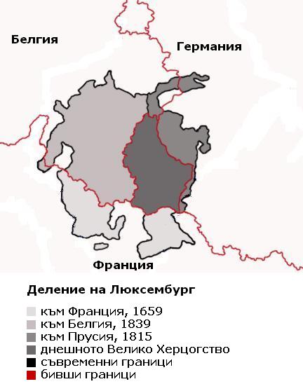
Български: Карта, показваща делението на Люксембург през вековете, с надписи на български.
English: Map showing the partition of Luxembourg through the centuries with Bulgarian explanations.
Français : Carte montrant la partition du Luxembourg à travers les siècles, avec explications en bulgare. |
| Date | |
| Source | |
| Author |
|
| Other versions |
|


| This is a retouched picture, which means that it has been digitally altered from its original version. Modifications: translated to Bulgarian. The original can be viewed here: LuxembourgPartitionsMap english.jpg:
|
I, the copyright holder of this work, hereby publish it under the following license:
| I, the copyright holder of this work, release this work into the public domain. This applies worldwide. In some countries this may not be legally possible; if so: I grant anyone the right to use this work for any purpose, without any conditions, unless such conditions are required by law. |
Original upload log edit
This image is a derivative work of the following images:
- File:LuxembourgPartitionsMap_english.jpg licensed with PD-self
- 2008-07-21T18:11:56Z Pretty Green 433x569 (47160 Bytes) {{Information |Description= As previous, with rivers removed from map for clarity |Source= previous version |Date= 21 July 2008 |Author= Spanish Inquisition, modified by Pretty Green |Permission= |other_versions= }}
- 2006-09-03T14:58:29Z Spanish Inquisition 433x569 (83793 Bytes) Map showing the partition of Luxembourg thorugh the centuries with english expanantions. Modification of the image LuxembourgPartitionsMap.png by user:QuartierLatin1968 14:10, 22 Apr 2005 (UTC). Author: user:Spanish_Inquisit
Uploaded with derivativeFX
File history
Click on a date/time to view the file as it appeared at that time.
| Date/Time | Thumbnail | Dimensions | User | Comment | |
|---|---|---|---|---|---|
| current | 14:20, 8 September 2009 | | 432 × 558 (46 KB) | Spiritia (talk | contribs) | {{Information |Description= {{bg|Карта, показваща делението на Люксевбург през вековете, с надписи на български. }} {{en|Map showing the partition of Luxembourg through the centuries with B |
You cannot overwrite this file.
File usage on Commons
The following 4 pages use this file:
File usage on other wikis
The following other wikis use this file:
- Usage on bg.wikipedia.org