File:LuxembourgPartitionsMap english.jpg
No higher resolution available.
LuxembourgPartitionsMap_english.jpg (433 × 569 pixels, file size: 46 KB, MIME type: image/jpeg)
Captions
Captions
Add a one-line explanation of what this file represents

|
This file has been superseded by LuxembourgPartitionsMap english.png. It is recommended to use the other file. Please note that deleting superseded images requires consent.
|

|
Summary edit
| Description |
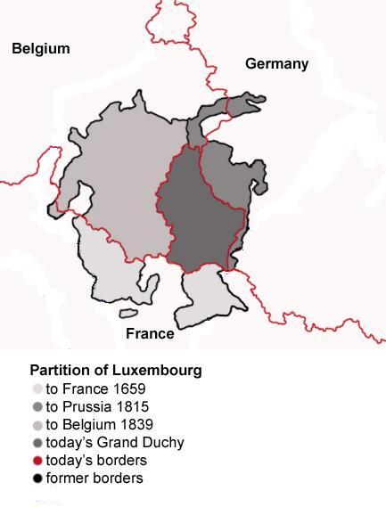
English: Map showing the partition of Luxembourg through the centuries.
Français : Carte montrant la partition du Luxembourg à travers les siècles, avec explications an anglais. |
| Date | |
| Source |
|
| Author | Spanish_Inquisition |
| Other versions |
|


Licensing edit
| I, the copyright holder of this work, release this work into the public domain. This applies worldwide. In some countries this may not be legally possible; if so: I grant anyone the right to use this work for any purpose, without any conditions, unless such conditions are required by law. |
File history
Click on a date/time to view the file as it appeared at that time.
| Date/Time | Thumbnail | Dimensions | User | Comment | |
|---|---|---|---|---|---|
| current | 18:11, 21 July 2008 | | 433 × 569 (46 KB) | Pretty Green~commonswiki (talk | contribs) | {{Information |Description= As previous, with rivers removed from map for clarity |Source= previous version |Date= 21 July 2008 |Author= Spanish Inquisition, modified by Pretty Green |Permission= |other_versions= }} |
| 14:58, 3 September 2006 |  | 433 × 569 (82 KB) | Spanish Inquisition (talk | contribs) | Map showing the partition of Luxembourg thorugh the centuries with english expanantions. Modification of the image LuxembourgPartitionsMap.png by user:QuartierLatin1968 14:10, 22 Apr 2005 (UTC). Author: user:Spanish_Inquisition Date: 3rd September 2006 |
You cannot overwrite this file.
File usage on Commons
The following 5 pages use this file:
File usage on other wikis
The following other wikis use this file:
- Usage on bg.wikipedia.org
- Usage on en.wikipedia.org
- Usage on he.wikipedia.org
- Usage on it.wikipedia.org
- Usage on ja.wikipedia.org
- Usage on mn.wikipedia.org
- Usage on no.wikipedia.org
- Usage on th.wikipedia.org
- Usage on vi.wikipedia.org