File:Luxemburg 1659–1839.svg

Size of this PNG preview of this SVG file: 574 × 599 pixels. Other resolutions: 230 × 240 pixels | 460 × 480 pixels | 736 × 768 pixels | 981 × 1,024 pixels | 1,962 × 2,048 pixels | 685 × 715 pixels.
Original file (SVG file, nominally 685 × 715 pixels, file size: 32 KB)
Captions
Captions
Add a one-line explanation of what this file represents
Summary edit
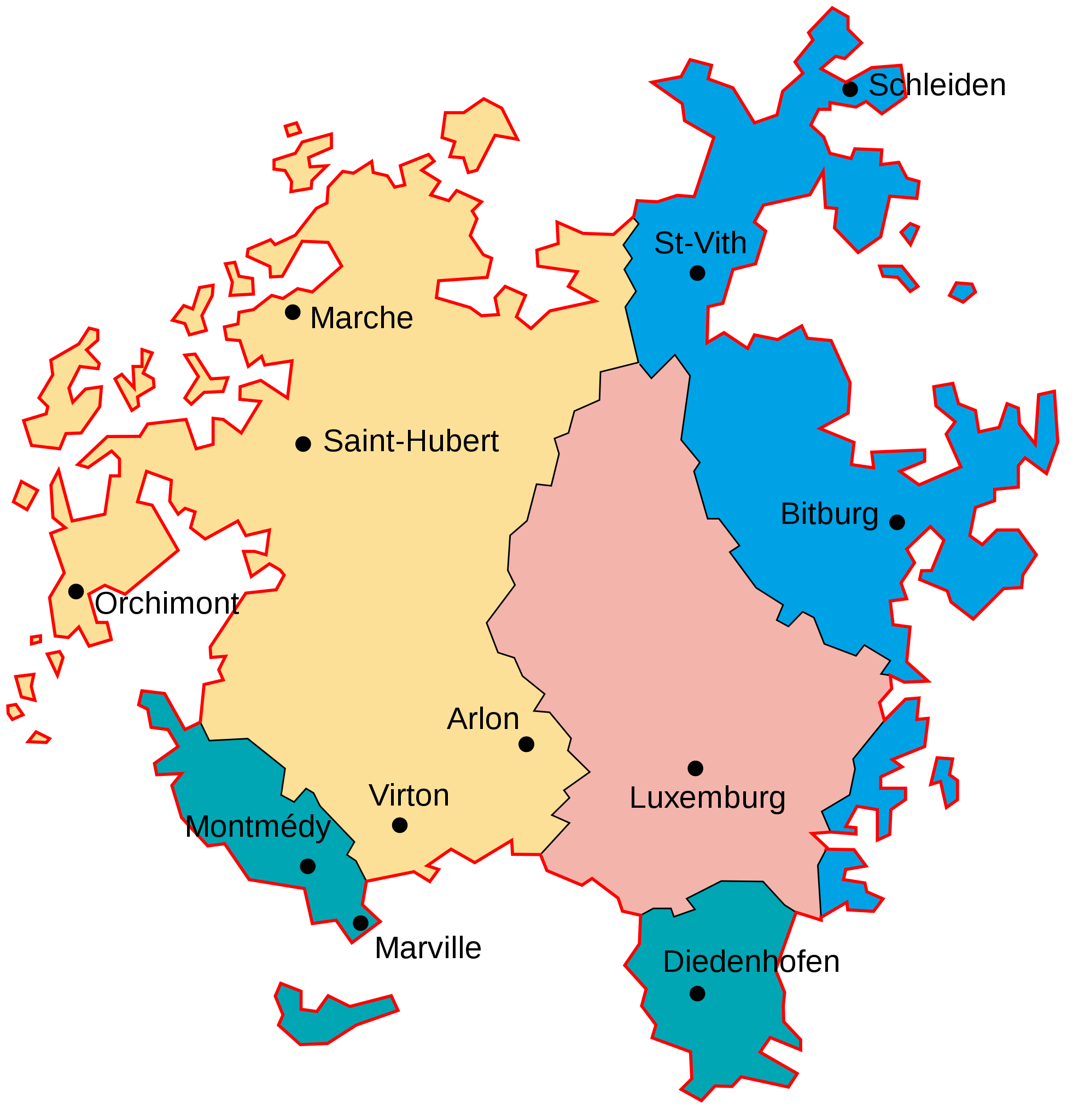
| Description |
Deutsch: Historische Entwicklung der Grenzen Luxemburgs im Zeitraum 1659 bis 1839.
Grenze der Herzogtum Luxemburg vor 1659
An Frankreich im Pyrenäenfrieden 1659
An Preußen im Wiener Kongress 1815
An die Vereinigten Niederlande/Belgien 1815/1839
Luxemburg seit 1839 English: Historical evolution of the borders of Luxembourg between 1659 and 1839.
Borders of the Duchy of Luxemburg before 1659
Lost to France by the Treaty of the Pyrenees in 1659
Lost to Prussia by the Congress of Vienna in 1815
Lost to Belgium by the Treaty of London in 1839
Luxembourg after 1839 Polski: Historyczny rozwój granic Luksemburga w latach 1659–1839.
Granice Księstwa Luksemburga sprzed 1659
Utrata na rzecz Francji na mocy pokoju pirenejskiego w 1659
Utrata na rzecz Prus na mocy kongresu wiedeńskiego w 1815
Utrata na rzecz Belgii na mocy traktatu londyńskiego w 1839
Luksemburg po 1839 |
||
| Date | |||
| Source | Own work, inspired by Karten Luxemburgs | ||
| Author | Furfur | ||
| Permission (Reusing this file) |
I, the copyright holder of this work, hereby publish it under the following licenses:
This file is licensed under the Creative Commons Attribution-Share Alike 4.0 International license.
You may select the license of your choice. |
||
| SVG development | This map was created with Adobe Illustrator. |

File history
Click on a date/time to view the file as it appeared at that time.
| Date/Time | Thumbnail | Dimensions | User | Comment | |
|---|---|---|---|---|---|
| current | 10:01, 28 September 2019 | | 685 × 715 (32 KB) | Furfur (talk | contribs) | == {{int:filedesc}} == {{Information |Description={{User:Medium69/Traduction}} {{de|1=Historische Entwicklung der Grenzen Luxemburgs im Zeitraum 1659 bis 1839.}} |Source={{own}}, inspired by [http://luxembourg.public.lu/de/cartes-du-luxembourg/index.html Karten Luxemburgs] |Date=2019-09-28 |Author={{U|Furfur}} |Permission={{self|GFDL|cc-by-sa-4.0}} |Other versions= |Other fields={{Igen|A|+|%|s=m}} }} Category:SVG maps showing history in German Category:Maps of the history of Luxembourg |
You cannot overwrite this file.
File usage on Commons
The following page uses this file:
File usage on other wikis
The following other wikis use this file:
- Usage on de.wikipedia.org
- Usage on lt.wikipedia.org
- Usage on pl.wikipedia.org