File:Münchner Nordring.png

Size of this preview: 800 × 351 pixels. Other resolutions: 320 × 140 pixels | 640 × 281 pixels | 1,024 × 449 pixels | 1,280 × 562 pixels | 2,560 × 1,123 pixels | 8,368 × 3,672 pixels.
Original file (8,368 × 3,672 pixels, file size: 14.24 MB, MIME type: image/png)
Captions
Captions
Add a one-line explanation of what this file represents
Summary edit
| Description |
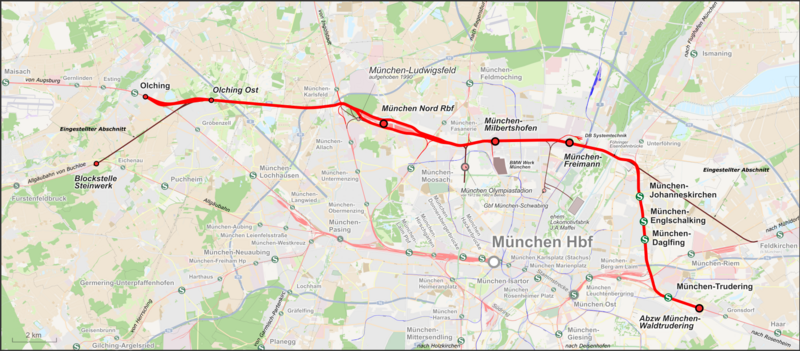
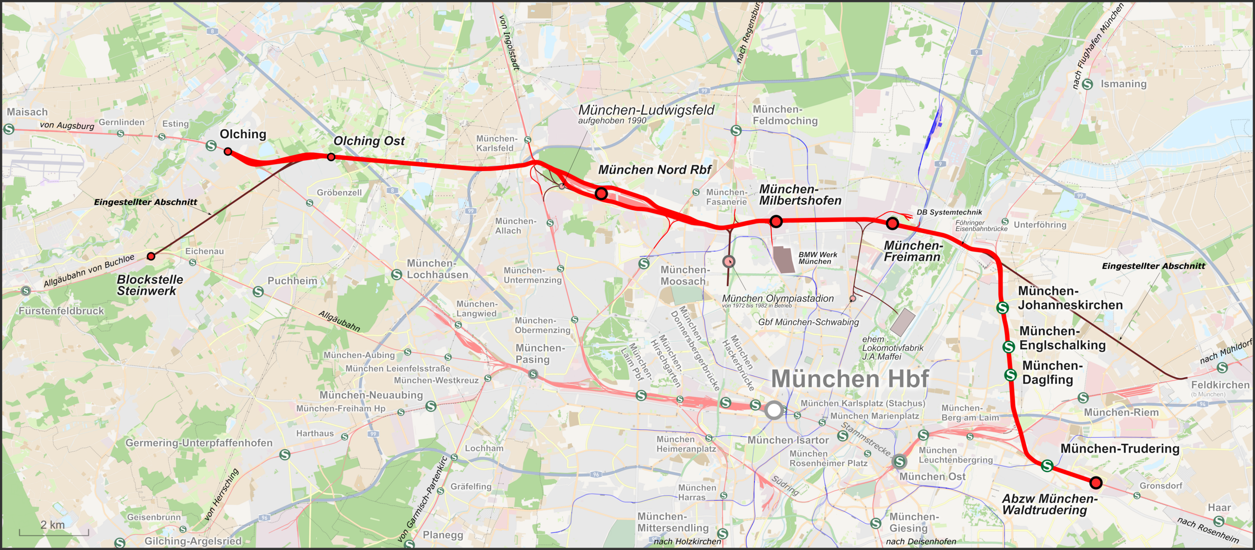
Deutsch: Karte des Münchner Nordring in Bayern, Deutschland |
| Date | |
| Source |
Own work Map was created using: |
| Author | |
| Permission (Reusing this file) |
Map data (c) OpenStreetMap (and) contributors, CC-BY-SA |
Licensing edit
This file is licensed under the Creative Commons Attribution-Share Alike 2.0 Generic license.
- You are free:
- to share – to copy, distribute and transmit the work
- to remix – to adapt the work
- Under the following conditions:
- attribution – You must give appropriate credit, provide a link to the license, and indicate if changes were made. You may do so in any reasonable manner, but not in any way that suggests the licensor endorses you or your use.
- share alike – If you remix, transform, or build upon the material, you must distribute your contributions under the same or compatible license as the original.
File history
Click on a date/time to view the file as it appeared at that time.
| Date/Time | Thumbnail | Dimensions | User | Comment | |
|---|---|---|---|---|---|
| current | 07:03, 11 April 2024 | | 8,368 × 3,672 (14.24 MB) | Pechristener (talk | contribs) | Grödener Spange entfernt |
| 23:43, 2 October 2016 |  | 8,926 × 3,917 (13.72 MB) | Pechristener (talk | contribs) | korr text | |
| 15:03, 26 September 2015 |  | 8,926 × 3,917 (13.7 MB) | Pechristener (talk | contribs) | München Karlsbad >> München Karlsfeld | |
| 00:05, 23 February 2015 |  | 8,926 × 3,917 (13.24 MB) | Pechristener (talk | contribs) | Hintergrund nicht mehr durchsichtig. | |
| 23:13, 22 February 2015 |  | 8,926 × 3,917 (15.68 MB) | Pechristener (talk | contribs) | == {{int:filedesc}} == {{Information |Description = {{de|1=Karte des Münchner Nordring in Bayern, Deutschland}} |Source ={{own}} Map was created using: *[http://www.openstreetmap.org/ Open Street Map] |Autho... |
You cannot overwrite this file.
File usage on Commons
The following 16 pages use this file:
- User:Chumwa/OgreBot/München/2015 September 21-30
- User:Chumwa/OgreBot/München/2016 October 1-10
- User:Chumwa/OgreBot/Potential transport maps/2016 October 1-10
- User:Chumwa/OgreBot/Public transport information/2015 February 19-28
- User:Chumwa/OgreBot/Public transport information/2015 September 21-30
- User:Chumwa/OgreBot/Public transport information/2016 October 1-10
- User:Chumwa/OgreBot/Public transport information/2024 April 11-20
- User:Chumwa/OgreBot/Transport Maps/2015 February 19-28
- User:Chumwa/OgreBot/Transport Maps/2015 September 21-30
- User:Chumwa/OgreBot/Transport Maps/2016 October 1-10
- User:Chumwa/OgreBot/Transport Maps/2024 April 11-20
- User:Chumwa/OgreBot/Travel and communication maps/2016 October 1-10
- User:Liesel/Rail transport/2015 February 19-28
- User:Nordlicht8/Rail Germany/2015 February 19-28
- User:Nordlicht8/Rail Germany/2015 September 21-30
- Category:Münchner Nordring
File usage on other wikis
The following other wikis use this file:
- Usage on de.wikipedia.org
- Usage on en.wikipedia.org
- Usage on hu.wikipedia.org
- Usage on www.wikidata.org