File:MACAUBUS ROUTEMAP 3X.png
Size of this preview: 337 × 599 pixels. Other resolutions: 135 × 240 pixels | 270 × 480 pixels | 432 × 768 pixels | 1,080 × 1,920 pixels.
Original file (1,080 × 1,920 pixels, file size: 216 KB, MIME type: image/png)
Captions
Captions
Add a one-line explanation of what this file represents
Summary edit
| Description |
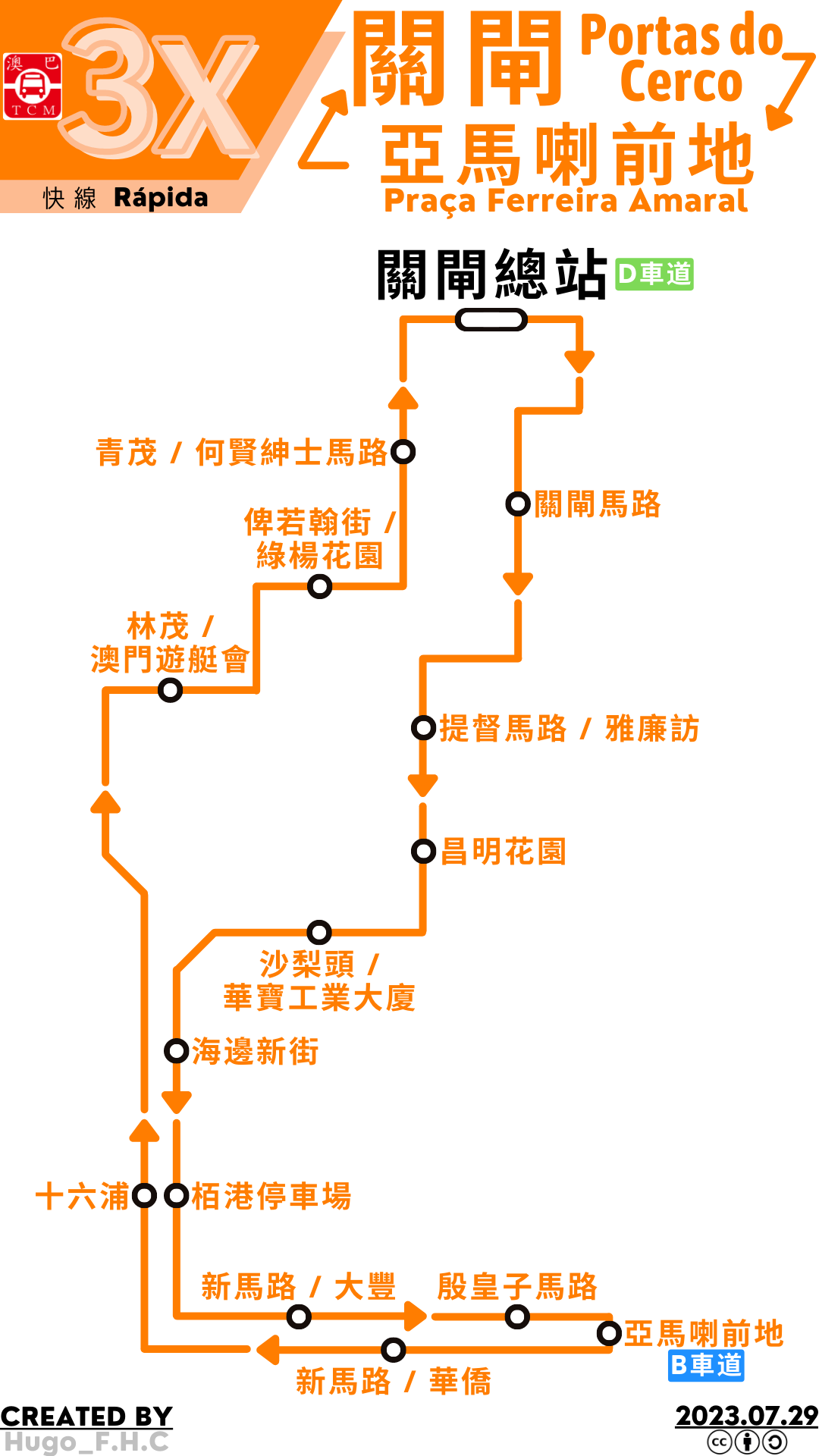
中文:澳門巴士3X路線的走線圖 |
| Date | |
| Source | 使用Canva程式製作 |
| Author | Hugo F.H.C |
Licensing edit
I, the copyright holder of this work, hereby publish it under the following licenses:

|
Permission is granted to copy, distribute and/or modify this document under the terms of the GNU Free Documentation License, Version 1.2 or any later version published by the Free Software Foundation; with no Invariant Sections, no Front-Cover Texts, and no Back-Cover Texts. A copy of the license is included in the section entitled GNU Free Documentation License. |
This file is licensed under the Creative Commons Attribution-Share Alike 4.0 International license.
- You are free:
- to share – to copy, distribute and transmit the work
- to remix – to adapt the work
- Under the following conditions:
- attribution – You must give appropriate credit, provide a link to the license, and indicate if changes were made. You may do so in any reasonable manner, but not in any way that suggests the licensor endorses you or your use.
- share alike – If you remix, transform, or build upon the material, you must distribute your contributions under the same or compatible license as the original.
You may select the license of your choice.
File history
Click on a date/time to view the file as it appeared at that time.
| Date/Time | Thumbnail | Dimensions | User | Comment | |
|---|---|---|---|---|---|
| current | 07:33, 29 July 2023 | | 1,080 × 1,920 (216 KB) | Hugo F.H.C (talk | contribs) | 路線圖更新 |
| 11:05, 21 January 2023 |  | 1,587 × 2,245 (300 KB) | Hugo F.H.C (talk | contribs) | 路線圖更新 | |
| 01:04, 23 August 2022 |  | 1,587 × 2,245 (291 KB) | Hugo F.H.C (talk | contribs) | 路線圖更新 | |
| 05:24, 28 July 2022 |  | 1,587 × 2,245 (284 KB) | Hugo F.H.C (talk | contribs) | 路線圖更新 | |
| 14:08, 2 July 2022 |  | 1,587 × 2,245 (274 KB) | Hugo F.H.C (talk | contribs) | 路線圖更新 | |
| 03:03, 27 May 2022 |  | 1,587 × 2,245 (273 KB) | Hugo F.H.C (talk | contribs) | 修改站名 | |
| 13:57, 1 April 2022 |  | 1,587 × 2,245 (265 KB) | Hugo F.H.C (talk | contribs) | 使用檔案上傳精靈上傳自製檔案 |
You cannot overwrite this file.
File usage on Commons
The following 9 pages use this file:
- User:Chumwa/OgreBot/Public transport information/2022 August 21-31
- User:Chumwa/OgreBot/Public transport information/2023 January 21-31
- User:Chumwa/OgreBot/Public transport information/2023 July 21-31
- User:Chumwa/OgreBot/Transport Maps/2022 August 21-31
- User:Chumwa/OgreBot/Transport Maps/2023 January 21-31
- User:Chumwa/OgreBot/Transport Maps/2023 July 21-31
- User:Chumwa/OgreBot/Travel and communication maps/2022 August 21-31
- User:Chumwa/OgreBot/Travel and communication maps/2023 January 21-31
- User:Chumwa/OgreBot/Travel and communication maps/2023 July 21-31
File usage on other wikis
The following other wikis use this file:
- Usage on zh.wikipedia.org