File:MAF airport map.PNG
Size of this preview: 390 × 599 pixels. Other resolutions: 156 × 240 pixels | 516 × 792 pixels.
Original file (516 × 792 pixels, file size: 66 KB, MIME type: image/png)
Captions
Captions
Add a one-line explanation of what this file represents
| Description |
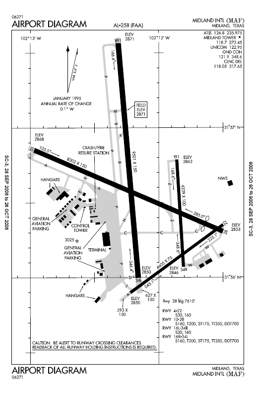
English: Airport map Midland International Airport. |
|||
| Source | ||||
| Author | ||||
| Permission (Reusing this file) |
|

Original upload log edit
The original description page was here. All following user names refer to en.wikipedia.
- 2006-10-28 01:38 MJHankel 516×792× (67436 bytes) Airport map Midland International Airport {{PD-USGov-FAA}}
File history
Click on a date/time to view the file as it appeared at that time.
| Date/Time | Thumbnail | Dimensions | User | Comment | |
|---|---|---|---|---|---|
| current | 00:16, 3 February 2010 | | 516 × 792 (66 KB) | File Upload Bot (Magnus Manske) (talk | contribs) | {{BotMoveToCommons|en.wikipedia|year={{subst:CURRENTYEAR}}|month={{subst:CURRENTMONTHNAME}}|day={{subst:CURRENTDAY}}}} {{Information |Description={{en|Airport map Midland International Airport en:commons:category:Midland International Airport [[: |
You cannot overwrite this file.
File usage on Commons
There are no pages that use this file.
File usage on other wikis
The following other wikis use this file:
- Usage on en.wikipedia.org
- Usage on fa.wikipedia.org
- Usage on ja.wikipedia.org
- Usage on tg.wikipedia.org
- Usage on vi.wikipedia.org