File:MC13-ESP0682…—Jezero, South Séítah.png

Original file (4,900 × 6,300 pixels, file size: 17.51 MB, MIME type: image/png)
Captions
Captions
Summary edit
| Description |
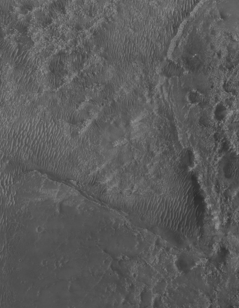
English: The base image for this clipping is the large ESP_068294_1985 MRO photo of the MC13 Syrtis Major quadrangle of Mars acquired with the High Resolution Imaging Experiment (HiRISE) camera aboard NASA’s Mars Reconnaissance Orbiter (MRO). This specific cutout displays the operations area of the first months of the Mars-2020 mission started in February 2021. Image encloses the soutern part of Séítah area in Jezero crater seen as a nose-shaped triangle jutting into the main crater floor from north-west.
The USGS/NASA geological map of the Jezero Crater region on Mars defines the area of Séítah as one of localities of the the Lower etched unit (NIe), which lies adjacent to the Jezero floor unit (Njf), embaying the NIe. Thus, in 2021 the path of Perseverance rover was laid along the geological the border between the two above-mentioned areas in a counterclockwise direction south from the landing site, seen in the upper right corner of this image. MRO’s mission is managed by NASA’s Jet Propulsion Laboratory, a division of Caltech in Pasadena, California, for NASA’s Science Mission Directorate. Lockheed Martin Space in Denver built the spacecraft. The University of Arizona in Tucson provided and operates HiRISE. Mars-2020 is the first mission to collect and cache Martian rock and regolith (broken rock and dust) and the key objective for the Perseverance rover is astrobiology, including the search for signs of ancient microbial life. JPL was built and manages NASA’s Jet Propulsion Laboratory, a division of the California Institute of Technology in Pasadena, CA, manages the operations of the Perseverance rover and the Mars Reconnaissance Orbiter for NASA’s Science Mission Directorate, Washington. The HiRISE camera was built by Ball Aerospace and Technology Corporation and is operated by the University of Arizona. Credits: NASA/JPL/UArizona |
| Date | |
| Source | https://www.uahirise.org/ESP_068294_1985 |
| Author | NASA/JPL/UArizona |
Licensing edit
| This file is in the public domain in the United States because it was solely created by NASA. NASA copyright policy states that "NASA material is not protected by copyright unless noted". (See Template:PD-USGov, NASA copyright policy page or JPL Image Use Policy.) | ||
 |
Warnings:
|
File history
Click on a date/time to view the file as it appeared at that time.
| Date/Time | Thumbnail | Dimensions | User | Comment | |
|---|---|---|---|---|---|
| current | 09:50, 22 August 2021 | | 4,900 × 6,300 (17.51 MB) | Cherurbino (talk | contribs) | Uploaded a work by NASA from https://www.uahirise.org/ESP_068294_1985 with UploadWizard |
You cannot overwrite this file.
File usage on Commons
There are no pages that use this file.
File usage on other wikis
The following other wikis use this file:
- Usage on ru.wikipedia.org