File:MR-Chita Station North Side-Track-Aerial photography 1982.jpg

Size of this preview: 800 × 439 pixels. Other resolutions: 320 × 176 pixels | 640 × 352 pixels | 1,024 × 562 pixels | 1,451 × 797 pixels.
Original file (1,451 × 797 pixels, file size: 1.16 MB, MIME type: image/jpeg)
Captions
Captions
Add a one-line explanation of what this file represents
Summary edit
| Description |
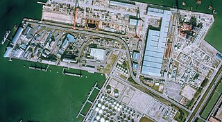
English: Around the Nagoya Rinkai Railway Chita Station Northern Side-track. 日本語: 名古屋臨海鉄道 知多駅 北側線 |
| Date | |
| Source |
|
| Author |
Licensing edit

|
The copyright holder of this file, Ministry of Land, Infrastructure, Transport and Tourism, allows anyone to use it for any purpose, provided that the copyright holder is properly attributed. Redistribution, derivative work, commercial use, and all other use is permitted. |
Attribution:
National Land Image Information (Color Aerial Photographs), created by Ministry of Land, Infrastructure, Transport and Tourism, distributed by Geospatial Information Authority of Japan
|

File history
Click on a date/time to view the file as it appeared at that time.
| Date/Time | Thumbnail | Dimensions | User | Comment | |
|---|---|---|---|---|---|
| current | 16:19, 16 June 2019 | | 1,451 × 797 (1.16 MB) | ButuCC (talk | contribs) | == {{int:filedesc}} == {{Information |description={{en|1=Around the Nagoya Rinkai Railway Chita Station Northern Side-track.}}{{ja|1=名古屋臨海鉄道 知多駅 北側線}} |date=1982-11-28 |source= *国土交通省「国土画像情報(カラー空中写真)」(配布元:国土地理院地図・空中写真閲覧サービス) **[https://mapps.gsi.go.jp/maplibSearch.do?specificationId=839341 整理番号 CCB823-C6D-8] |author={{ja|国土地理院、ButuCCが加工。}} {{en|Geospatial Information Authority of Japan, modified by [[User:ButuCC|B... |
You cannot overwrite this file.
File usage on Commons
The following 2 pages use this file:
File usage on other wikis
The following other wikis use this file:
- Usage on ja.wikipedia.org