File:Madura Island topographic map - ru.svg

Size of this PNG preview of this SVG file: 800 × 269 pixels. Other resolutions: 320 × 107 pixels | 640 × 215 pixels | 1,024 × 344 pixels | 1,280 × 430 pixels | 2,560 × 859 pixels | 2,401 × 806 pixels.
Original file (SVG file, nominally 2,401 × 806 pixels, file size: 1.09 MB)
Captions
Captions
Add a one-line explanation of what this file represents
Summary edit
| Description |
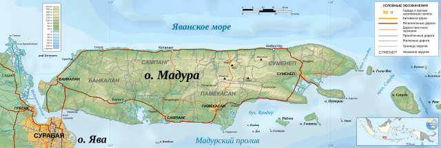
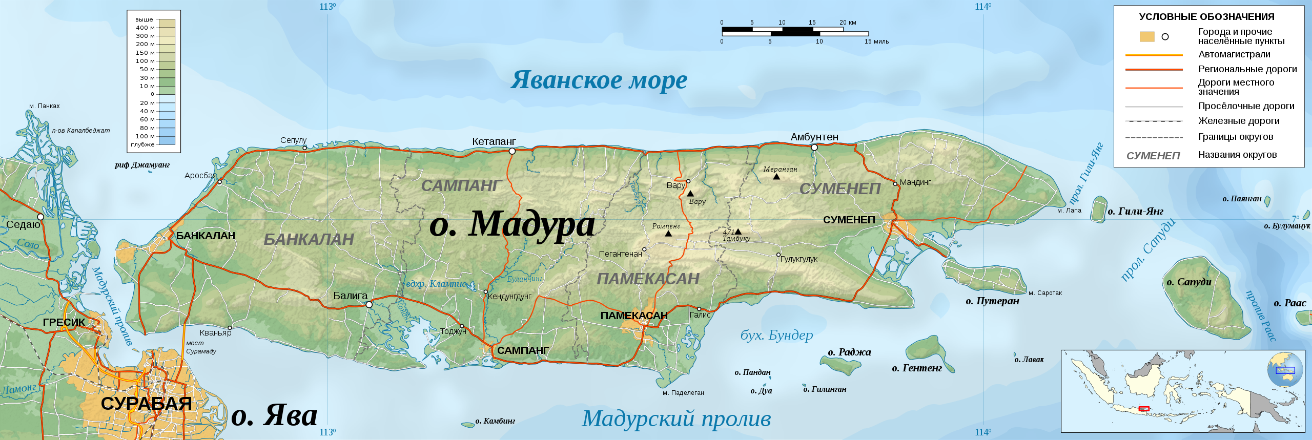
Русский: Топографическая карта индонезийского острова Мадура.
English: Topographic map of Madura Island.
Bahasa Indonesia: Peta topografi Pulau Madura.
Français : La carte topographique de de l île Madura.
Deutsch: Topographische Karte fon Madura.
Mercator projection; WGS84 datum; shaded relief. Geographic limits of the map :
|
| Date | |
| Source |
Own work 
|
| Author | Kaidor |
| SVG development |
| Camera location | | View this and other nearby images on: OpenStreetMap |
|---|
Licensing edit
This image uses high-resolution digital topography data from NASA's Shuttle Radar Topography Mission (SRTM) at JPL-Caltech [1]. It is in the public domain in the United States.
|
 | |
| This work contains information from OpenStreetMap, which is made available under the Open Database License (ODbL).
The ODbL does not require any particular license for maps produced from ODbL data. Prior to 1 August 2020, map tiles produced by the OpenStreetMap Foundation were licensed under the CC-BY-SA-2.0 license. Maps produced by other people may be subject to other licences. |
I, the copyright holder of this work, hereby publish it under the following license:
This file is licensed under the Creative Commons Attribution-Share Alike 4.0 International license.
- You are free:
- to share – to copy, distribute and transmit the work
- to remix – to adapt the work
- Under the following conditions:
- attribution – You must give appropriate credit, provide a link to the license, and indicate if changes were made. You may do so in any reasonable manner, but not in any way that suggests the licensor endorses you or your use.
- share alike – If you remix, transform, or build upon the material, you must distribute your contributions under the same or compatible license as the original.
File history
Click on a date/time to view the file as it appeared at that time.
| Date/Time | Thumbnail | Dimensions | User | Comment | |
|---|---|---|---|---|---|
| current | 09:51, 4 March 2018 | 2,401 × 806 (1.09 MB) | Kaidor (talk | contribs) | Порядок слоёв | |
| 18:12, 1 March 2018 | 2,401 × 806 (1.09 MB) | Kaidor (talk | contribs) | добавлены провинции | ||
| 18:06, 28 February 2018 | 2,401 × 806 (1.08 MB) | Kaidor (talk | contribs) | Уточнения в надписях | ||
| 16:32, 27 February 2018 | 2,401 × 806 (1.08 MB) | Kaidor (talk | contribs) | User created page with UploadWizard |
You cannot overwrite this file.
File usage on Commons
The following 6 pages use this file:
- User:Kaidor
- Commons:WikiProject Aviation/recent uploads/2018 February 27
- Commons:WikiProject Aviation/recent uploads/2018 February 28
- Commons:WikiProject Aviation/recent uploads/2018 March 1
- Commons:WikiProject Aviation/recent uploads/2018 March 4
- File:Administrative divisions of Madura Island - ru.svg
File usage on other wikis
The following other wikis use this file:
- Usage on fr.wikipedia.org
- Usage on hy.wikipedia.org
- Usage on id.wikipedia.org
- Kabupaten Sumenep
- Ambunten, Sumenep
- Lenteng, Sumenep
- Manding, Sumenep
- Kalianget, Sumenep
- Batang Batang, Sumenep
- Nonggunong, Sumenep
- Guluk-Guluk, Sumenep
- Giligenting, Sumenep
- Pasongsongan, Sumenep
- Batuputih, Sumenep
- Bluto, Sumenep
- Dasuk, Sumenep
- Talango, Sumenep
- Dungkek, Sumenep
- Gayam, Sumenep
- Rubaru, Sumenep
- Saronggi, Sumenep
- Raas, Sumenep
- Ganding, Sumenep
- Gapura, Sumenep
- Kota Sumenep, Sumenep
- Batuan, Sumenep
- Modul:Location map/data/Indonesia Madura
- Modul:Location map/data/Indonesia Madura/doc
- Usage on ru.wikipedia.org