File:Magnetic image of council circle.jpg
No higher resolution available.
Magnetic_image_of_council_circle.jpg (600 × 335 pixels, file size: 142 KB, MIME type: image/jpeg)
Captions
Captions
Add a one-line explanation of what this file represents

|
This file was moved to Wikimedia Commons from en.wikipedia using a bot script. All source information is still present. It requires review. Additionally, there may be errors in any or all of the information fields; information on this file should not be considered reliable and the file should not be used until it has been reviewed and any needed corrections have been made. Once the review has been completed, this template should be removed. For details about this file, see below. Check now! |
| Description |
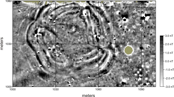
English: Magnetic field gradient image of a council circle located on a Great Bend aspect archaeological site in central Kansas. The data reveal a complex earthen works feature with numerous internal and external features. The main feature appears to be some 60 meters in diameter and may be described as a complex circular or oval shape with four or more lobes. The outer limits of the feature appear as concentric bands of positive and negative signal. There are approximately four to five of these bands. It is not clear whether these bands represent re-building events, contraction/expansion of the structure over time, or are part of the original structure plan. The central portion of the structure is devoid of this banding, but does contain numerous anomalies that appear to represent internal archaeological features. Many anomalies are visible outside the main structure as well. These anomalies appear to represent archaeological features external to the council circle.
Magnetic survey is one of several non-invasive mapping methods commonly used in the discipline of archaeological geophysics. Source: http://www.archaeophysics.com/sharps/ |
| Date | 14 March 2008 (original upload date) |
| Source | Transferred from en.wikipedia to Commons by Dmitri Lytov using CommonsHelper. |
| Author | Pöhönen at English Wikipedia |
Licensing edit
Pöhönen at English Wikipedia, the copyright holder of this work, hereby publishes it under the following licenses:
This file is licensed under the Creative Commons Attribution-Share Alike 3.0 Unported license.
Attribution: Pöhönen at English Wikipedia
- You are free:
- to share – to copy, distribute and transmit the work
- to remix – to adapt the work
- Under the following conditions:
- attribution – You must give appropriate credit, provide a link to the license, and indicate if changes were made. You may do so in any reasonable manner, but not in any way that suggests the licensor endorses you or your use.
- share alike – If you remix, transform, or build upon the material, you must distribute your contributions under the same or compatible license as the original.

|
Permission is granted to copy, distribute and/or modify this document under the terms of the GNU Free Documentation License, Version 1.2 or any later version published by the Free Software Foundation; with no Invariant Sections, no Front-Cover Texts, and no Back-Cover Texts. A copy of the license is included in the section entitled GNU Free Documentation License. |
You may select the license of your choice.
Original upload log edit
The original description page was here. All following user names refer to en.wikipedia.
- 2008-03-14 19:24 Pöhönen 600×335× (145906 bytes) {{Information |Description=Magnetic field gradient image of a council circle at a Great Bend aspect archaeological site in central Kansas. The image was created using non-destructive geophysical survey methods. |Source=http://www.archaeophysics.com/sha
File history
Click on a date/time to view the file as it appeared at that time.
| Date/Time | Thumbnail | Dimensions | User | Comment | |
|---|---|---|---|---|---|
| current | 03:49, 4 August 2009 | | 600 × 335 (142 KB) | File Upload Bot (Magnus Manske) (talk | contribs) | {{BotMoveToCommons|en.wikipedia|year={{subst:CURRENTYEAR}}|month={{subst:CURRENTMONTHNAME}}|day={{subst:CURRENTDAY}}}} {{Information |Description={{en|Magnetic field gradient image of a council circle located on a Great Bend aspect archaeological site in |
You cannot overwrite this file.
File usage on Commons
There are no pages that use this file.
File usage on other wikis
The following other wikis use this file:
- Usage on en.wikipedia.org
- Usage on ru.wikipedia.org
- Usage on uk.wikipedia.org