File:Maguindanao 2011 Division Map.jpg

Size of this preview: 626 × 599 pixels. Other resolutions: 251 × 240 pixels | 501 × 480 pixels | 802 × 768 pixels | 1,250 × 1,197 pixels.
Original file (1,250 × 1,197 pixels, file size: 297 KB, MIME type: image/jpeg)
Captions
Captions
Add a one-line explanation of what this file represents
Summary edit
| Description |
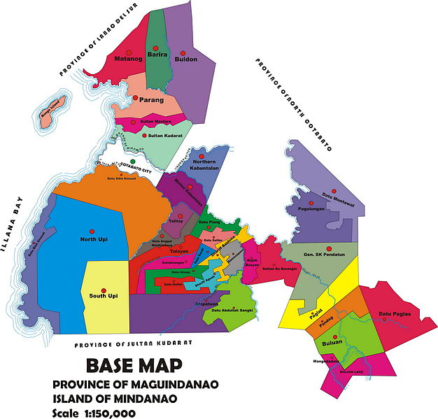
English: Political Map of Maguindanao as of September 2011. |
| Source | www.maguindanao.gov.ph. |
| Author | Exec8 |
| Permission (Reusing this file) |
Media is on public domain as it is created by an employee of the Philippine government under Philippine Intellectual Property Act and expressed permission for any legal reuse has been accorded to the uploader by the Local Government of the Province of Maguindanao. |
Licensing edit
I, the copyright holder of this work, hereby publish it under the following licenses:
This file is licensed under the Creative Commons Attribution-Share Alike 3.0 Unported license.
- You are free:
- to share – to copy, distribute and transmit the work
- to remix – to adapt the work
- Under the following conditions:
- attribution – You must give appropriate credit, provide a link to the license, and indicate if changes were made. You may do so in any reasonable manner, but not in any way that suggests the licensor endorses you or your use.
- share alike – If you remix, transform, or build upon the material, you must distribute your contributions under the same or compatible license as the original.

|
Permission is granted to copy, distribute and/or modify this document under the terms of the GNU Free Documentation License, Version 1.2 or any later version published by the Free Software Foundation; with no Invariant Sections, no Front-Cover Texts, and no Back-Cover Texts. A copy of the license is included in the section entitled GNU Free Documentation License. |
You may select the license of your choice.
File history
Click on a date/time to view the file as it appeared at that time.
| Date/Time | Thumbnail | Dimensions | User | Comment | |
|---|---|---|---|---|---|
| current | 18:18, 18 September 2013 | | 1,250 × 1,197 (297 KB) | Exec8 (talk | contribs) | {{Information |Description ={{en|1=Political Map of Maguindanao as of September 2011. }} |Source ={{own}} |Author =Exec8 |Date = |Permission = |other_versions = }} Category:Maguindanao |
You cannot overwrite this file.
File usage on Commons
There are no pages that use this file.