File:Mali map.png
No higher resolution available.
Mali_map.png (350 × 376 pixels, file size: 11 KB, MIME type: image/png)
Captions
Captions
Add a one-line explanation of what this file represents

|
This locator map image could be re-created using vector graphics as an SVG file. This has several advantages; see Commons:Media for cleanup for more information. If an SVG form of this image is available, please upload it and afterwards replace this template with
{{vector version available|new image name}}.
It is recommended to name the SVG file “Mali map.svg”—then the template Vector version available (or Vva) does not need the new image name parameter. |
Summary edit
| Description |
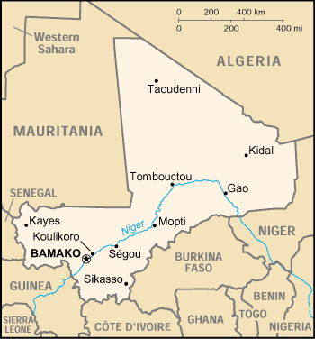
English: Map of Mali |
| Date | |
| Source | https://www.cia.gov/library/publications/the-world-factbook/geos/ml.html |
| Author | CIA |
Licensing edit
| This image is a work of a Central Intelligence Agency employee, taken or made as part of that person's official duties. As a Work of the United States Government, this image or media is in the public domain in the United States.
|

|
File history
Click on a date/time to view the file as it appeared at that time.
| Date/Time | Thumbnail | Dimensions | User | Comment | |
|---|---|---|---|---|---|
| current | 21:03, 3 March 2005 | | 350 × 376 (11 KB) | Alfio (talk | contribs) | CIA map of Mali |
You cannot overwrite this file.
File usage on Commons
The following 6 pages use this file:
- Atlas of Mali
- Maps of Mali
- Índice de países
- File:Mali-CIA WFB Map (2004).png (file redirect)
- File:Mali.gif (file redirect)
- File:Ml-map.png (file redirect)
.png&redirect=no)
File usage on other wikis
The following other wikis use this file:
- Usage on als.wikipedia.org
- Usage on am.wikipedia.org
- Usage on ast.wikipedia.org
- Usage on bjn.wikipedia.org
- Usage on ca.wikipedia.org
- Usage on ceb.wikipedia.org
- Usage on da.wikipedia.org
- Usage on de.wikivoyage.org
- Usage on en.wikipedia.org
- Usage on es.wikipedia.org
- Usage on eu.wikipedia.org
- Usage on fa.wikipedia.org
- Usage on fi.wikipedia.org
- Usage on fo.wikipedia.org
- Usage on fr.wikipedia.org
- Usage on he.wikipedia.org
- Usage on hi.wiktionary.org
- Usage on hu.wikipedia.org
- Usage on hu.wiktionary.org
- Usage on id.wikipedia.org
- Usage on io.wikipedia.org
- Usage on ja.wikipedia.org
- Usage on jv.wikipedia.org
- Usage on ko.wikipedia.org
- Usage on mr.wikipedia.org
- Usage on nds.wikipedia.org
- Usage on nl.wikipedia.org
- Usage on no.wikipedia.org
- Usage on oc.wikipedia.org
- Usage on pl.wikipedia.org
- Usage on pt.wikipedia.org
- Usage on ro.wikipedia.org
- Usage on ru.wikipedia.org
View more global usage of this file.