File:Manatvs gelegen op de Noot Riuier (Manhattan located at the North River) Map J Vinckeboons 1639 (LOC 97683586).jpg

Size of this preview: 800 × 575 pixels. Other resolutions: 320 × 230 pixels | 640 × 460 pixels | 1,024 × 736 pixels | 1,280 × 920 pixels | 2,560 × 1,839 pixels | 8,752 × 6,288 pixels.
Original file (8,752 × 6,288 pixels, file size: 7.95 MB, MIME type: image/jpeg)
Captions
Captions
Add a one-line explanation of what this file represents
Summary edit
| Description |
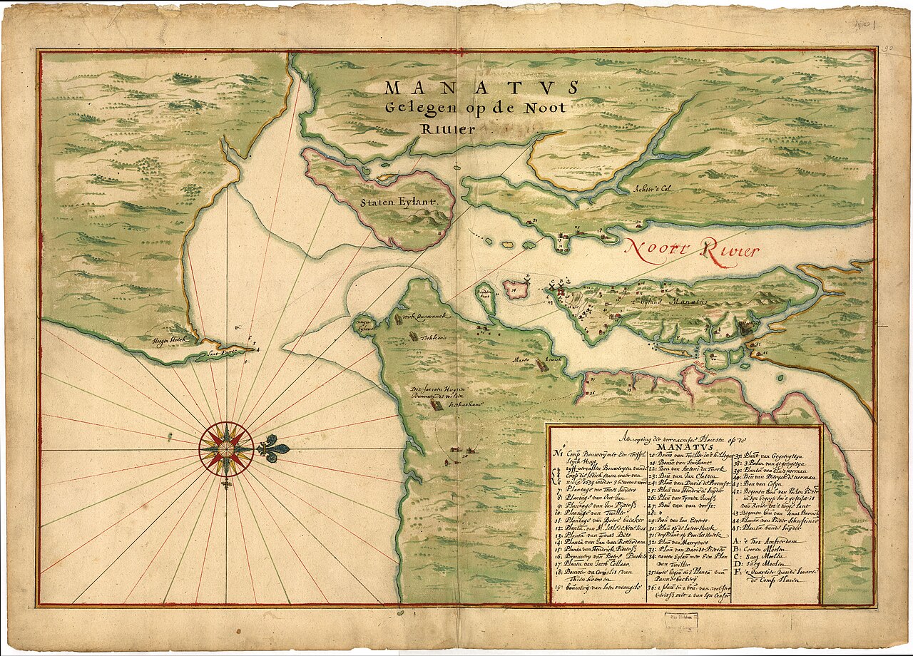
English: Manuscript. Pen-and-ink and watercolor. Covers New York City region. Pictorial map showing buildings and points of interest. Depths shown by soundings. Available also through the Library of Congress Web site as a raster image. Described in Terrae incognitae, v. xvi, 1984. Richard W. Stephenson's The Henry Harrisse collection ... , p. 40; the third volume has binder's title "Manuscript maps of New-Netherland and Manhattan drawn on the spot by Joan Vingboons in 1639." Includes index of buildings with householders' names. Vault |
||
| Title | Manatvs gelegen op de Noot [sic] Riuier. | ||
| Shelf ID | G3291.S12 coll .H3 | ||
| Date | |||
| Source | https://www.loc.gov/item/97683586/ | ||
| Author | Vinckeboons, Joan; Library Of Congress | ||
| Permission (Reusing this file) |
|
||
| Other versions |
|
||
| Location | New York Region · Manhattan (New York) · New York City · United States · New York · New York (State) · Manhattan | ||
| Part of | American Memory · Cities And Towns · Catalog · Geography And Map Division · Discovery And Exploration | ||
| Subject | New York Region · Manhattan (New York) · Manhattan (New York, N.Y.) · New York (N.Y.) · United States · Maps · Early Works To 1800 · New York · Real Property · New York (State) |


_Map_J_Vinckeboons_1639_(LOC_97683586).jpg&action=edit§ion=1)
Licensing edit
_Map_J_Vinckeboons_1639_(LOC_97683586).jpg&action=edit§ion=2)
|
This is a faithful photographic reproduction of a two-dimensional, public domain work of art. The work of art itself is in the public domain for the following reason:
The official position taken by the Wikimedia Foundation is that "faithful reproductions of two-dimensional public domain works of art are public domain".
This photographic reproduction is therefore also considered to be in the public domain in the United States. In other jurisdictions, re-use of this content may be restricted; see Reuse of PD-Art photographs for details. | ||||
File history
Click on a date/time to view the file as it appeared at that time.
| Date/Time | Thumbnail | Dimensions | User | Comment | |
|---|---|---|---|---|---|
| current | 23:23, 14 May 2018 | | 8,752 × 6,288 (7.95 MB) | Fæ (talk | contribs) | LOC Maps https://www.loc.gov/item/97683586/ #8666 |
You cannot overwrite this file.
File usage on Commons
The following 2 pages use this file:
_Riuier._LOC_97683586.jpg&redirect=no)
_Map_J_Vinckeboons_1639_(LOC_97683586).jpg&oldid=851243725)