File:Mancos Shale badlands (Upper Cretaceous; Book Cliffs region, eastern Utah, USA) 2 (30213623096).jpg

Original file (3,006 × 1,297 pixels, file size: 2.96 MB, MIME type: image/jpeg)
Captions
Captions
Summary edit
_2_(30213623096).jpg&action=edit§ion=1)
| Description |
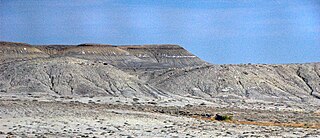
Shales in the Cretaceous of Utah, USA. The Mancos Shale is a thick, widespread, dark-colored, deep-water marine shale unit of Late Cretaceous age in western America. Outcrops occur in Colorado, Utah, Arizona, and New Mexico. The formation ranges from sparsely fossiliferous shales to fossiliferous calcareous shales. The Mancos Shale has an intertonguing relationship with the Dakota Sandstone - many sections have coarse-grained siliciclastic intervals broadly interbedded with fine-grained siliciclastics. Cretaceous-aged marine deposits are widespread in western North America - they represent sedimentation during a sea level highstand. During the Cretaceous, global sea level was so high that an ocean (the Western Interior Seaway) separated eastern and western North America. The Cretaceous transgression was a result of relatively rapid seafloor spreading rates (tectonic divergence) in some oceans basins. This lifted considerable portions of the seafloor, which raised global sea levels. The Mancos Shale is a non-weathering resistant unit and frequently forms distinctive, mottled grayish badlands. "Badlands" refers to a landscape unsuitable for farming. Such terrains are complexly dissected (eroded), have steep slopes, relatively soft rocks (usually shale), little to no soil, and little to no vegetation. Good examples of badlands topography are the Book Cliffs of eastern Utah, the Chinle Formation badlands of Arizona, the White River badlands of South Dakota (Badlands National Park), and the Little Missouri badlands of North Dakota (Roosevelt National Park). Stratigraphy: Mancos Shale, Turonian to Campanian Stages, Upper Cretaceous Locality: view from Interstate 70 in the Book Cliffs area, eastern Utah, USA Geology partly synthesized from: Frazier & Schwimmer (1987) - Regional Stratigraphy of North America. 719 pp. |
| Date | |
| Source | Mancos Shale badlands (Upper Cretaceous; Book Cliffs region, eastern Utah, USA) 2 |
| Author | James St. John |
Licensing edit
_2_(30213623096).jpg&action=edit§ion=2)
- You are free:
- to share – to copy, distribute and transmit the work
- to remix – to adapt the work
- Under the following conditions:
- attribution – You must give appropriate credit, provide a link to the license, and indicate if changes were made. You may do so in any reasonable manner, but not in any way that suggests the licensor endorses you or your use.
| This image was originally posted to Flickr by James St. John at https://flickr.com/photos/47445767@N05/30213623096. It was reviewed on 1 December 2019 by FlickreviewR 2 and was confirmed to be licensed under the terms of the cc-by-2.0. |
File history
Click on a date/time to view the file as it appeared at that time.
| Date/Time | Thumbnail | Dimensions | User | Comment | |
|---|---|---|---|---|---|
| current | 08:58, 1 December 2019 | | 3,006 × 1,297 (2.96 MB) | Ser Amantio di Nicolao (talk | contribs) | Transferred from Flickr via #flickr2commons |
You cannot overwrite this file.
File usage on Commons
There are no pages that use this file.
_2_(30213623096).jpg&oldid=610512464)