File:Mandatory signs around the world.svg

Size of this PNG preview of this SVG file: 800 × 407 pixels. Other resolutions: 320 × 163 pixels | 640 × 325 pixels | 1,024 × 520 pixels | 1,280 × 650 pixels | 2,560 × 1,301 pixels | 2,755 × 1,400 pixels.
Original file (SVG file, nominally 2,755 × 1,400 pixels, file size: 1.19 MB)
Captions
Captions
Add a one-line explanation of what this file represents
Summary edit
| Description |
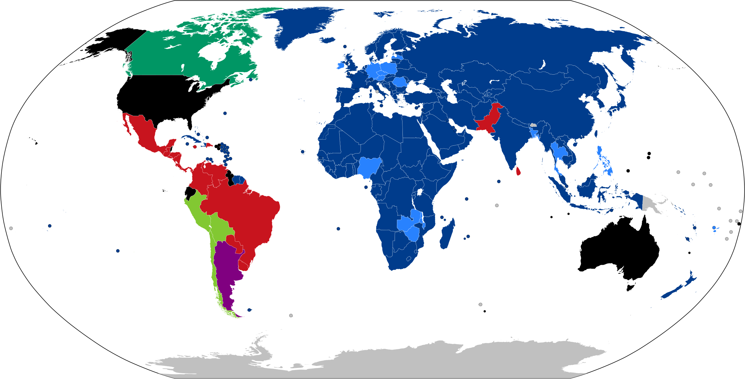
English (en): Standard design for mandatory instruction road signs by country
Uses Uses Uses Uses a combination of Uses a combination of Uses Does not use this type of sign No information
|
| Date | |
| Source | |
| Author | Fry1989 Fry1989 |
| SVG development |
Licensing edit
I, the copyright holder of this work, hereby publish it under the following license:
This file is licensed under the Creative Commons Attribution-Share Alike 4.0 International license.
- You are free:
- to share – to copy, distribute and transmit the work
- to remix – to adapt the work
- Under the following conditions:
- attribution – You must give appropriate credit, provide a link to the license, and indicate if changes were made. You may do so in any reasonable manner, but not in any way that suggests the licensor endorses you or your use.
- share alike – If you remix, transform, or build upon the material, you must distribute your contributions under the same or compatible license as the original.
File history
Click on a date/time to view the file as it appeared at that time.
| Date/Time | Thumbnail | Dimensions | User | Comment | |
|---|---|---|---|---|---|
| current | 00:59, 9 January 2022 | | 2,755 × 1,400 (1.19 MB) | Fry1989 (talk | contribs) | Romania |
| 15:22, 2 October 2021 |  | 2,755 × 1,400 (1.19 MB) | Fry1989 (talk | contribs) | Update | |
| 18:35, 5 September 2021 |  | 2,755 × 1,400 (1.19 MB) | Fry1989 (talk | contribs) | Updates | |
| 17:20, 29 August 2021 |  | 2,755 × 1,400 (1.19 MB) | Gohkenytp723 (talk | contribs) | East African Community (http://www.eac.int/infrastructure/index.php?option=com_docman&task=doc_download&gid=123&Itemid=154) | |
| 15:54, 29 August 2021 |  | 2,755 × 1,400 (1.19 MB) | Fry1989 (talk | contribs) | Bhutan | |
| 22:48, 23 August 2021 |  | 2,755 × 1,400 (1.19 MB) | Fry1989 (talk | contribs) | Overhaul map, colour contrast | |
| 23:36, 27 January 2020 |  | 855 × 434 (1.76 MB) | Fry1989 (talk | contribs) | Argentina | |
| 00:39, 16 October 2018 |  | 855 × 434 (1.76 MB) | Fry1989 (talk | contribs) | Burma | |
| 19:25, 1 December 2017 |  | 855 × 434 (1.76 MB) | Fry1989 (talk | contribs) | More countries | |
| 17:46, 30 November 2017 |  | 855 × 434 (1.76 MB) | Fry1989 (talk | contribs) | Malawi, India appears to have switched over but is very inconsistent |
You cannot overwrite this file.
File usage on Commons
The following 36 pages use this file:
- User:Chumwa/OgreBot/Potential transport maps/2016 March 11-20
- User:Chumwa/OgreBot/Potential transport maps/2016 May 21-31
- User:Chumwa/OgreBot/Potential transport maps/2017 December 1-10
- User:Chumwa/OgreBot/Potential transport maps/2017 November 21-30
- User:Chumwa/OgreBot/Potential transport maps/2017 October 11-20
- User:Chumwa/OgreBot/Potential transport maps/2017 October 21-31
- User:Chumwa/OgreBot/Potential transport maps/2018 October 11-20
- User:Chumwa/OgreBot/Potential transport maps/2020 January 21-31
- User:Chumwa/OgreBot/Transport Maps/2015 April 11-20
- User:Chumwa/OgreBot/Transport Maps/2015 April 21-30
- User:Chumwa/OgreBot/Transport Maps/2015 July 1-10
- User:Chumwa/OgreBot/Transport Maps/2015 May 1-10
- User:Chumwa/OgreBot/Transport Maps/2015 May 11-20
- User:Chumwa/OgreBot/Transport Maps/2016 March 11-20
- User:Chumwa/OgreBot/Transport Maps/2016 May 21-31
- User:Chumwa/OgreBot/Transport Maps/2017 December 1-10
- User:Chumwa/OgreBot/Transport Maps/2017 November 21-30
- User:Chumwa/OgreBot/Transport Maps/2017 October 11-20
- User:Chumwa/OgreBot/Transport Maps/2017 October 21-31
- User:Chumwa/OgreBot/Transport Maps/2018 October 11-20
- User:Chumwa/OgreBot/Transport Maps/2020 January 21-31
- User:Chumwa/OgreBot/Transport Maps/2021 October 1-10
- User:Chumwa/OgreBot/Transport Maps/2022 January 1-10
- User:Chumwa/OgreBot/Travel and communication maps/2016 March 11-20
- User:Chumwa/OgreBot/Travel and communication maps/2016 May 21-31
- User:Chumwa/OgreBot/Travel and communication maps/2017 December 1-10
- User:Chumwa/OgreBot/Travel and communication maps/2017 November 21-30
- User:Chumwa/OgreBot/Travel and communication maps/2017 October 11-20
- User:Chumwa/OgreBot/Travel and communication maps/2017 October 21-31
- User:Chumwa/OgreBot/Travel and communication maps/2018 October 11-20
- User:Fry1989/Gallery
- User:Fry1989/Gallery/Road Signs/Vienna Convention on Road Signs and Signals
- User talk:Fry1989/Archive 6
- User talk:Fry1989/Archive 7
- Commons:Files used on the AARoads Wiki/53
- File:Manditory signs around the World.svg (file redirect)
File usage on other wikis
The following other wikis use this file:
- Usage on ba.wikipedia.org
- Usage on en.wikipedia.org
- Usage on fi.wikipedia.org
- Usage on fr.wikipedia.org
- Usage on fr.wikibooks.org
- Usage on it.wikipedia.org
- Usage on kk.wikipedia.org
- Usage on lmo.wikipedia.org
- Usage on pl.wikipedia.org
- Usage on ru.wikipedia.org
- Usage on sv.wikipedia.org
- Usage on te.wikipedia.org
- Usage on tr.wikipedia.org
- Usage on uk.wikipedia.org