File:Mangystau, administrative divisions - de - colored.svg

Size of this PNG preview of this SVG file: 521 × 599 pixels. Other resolutions: 209 × 240 pixels | 417 × 480 pixels | 668 × 768 pixels | 891 × 1,024 pixels | 1,781 × 2,048 pixels | 881 × 1,013 pixels.
Original file (SVG file, nominally 881 × 1,013 pixels, file size: 165 KB)
Captions
Captions
Add a one-line explanation of what this file represents
Summary edit
| Description |
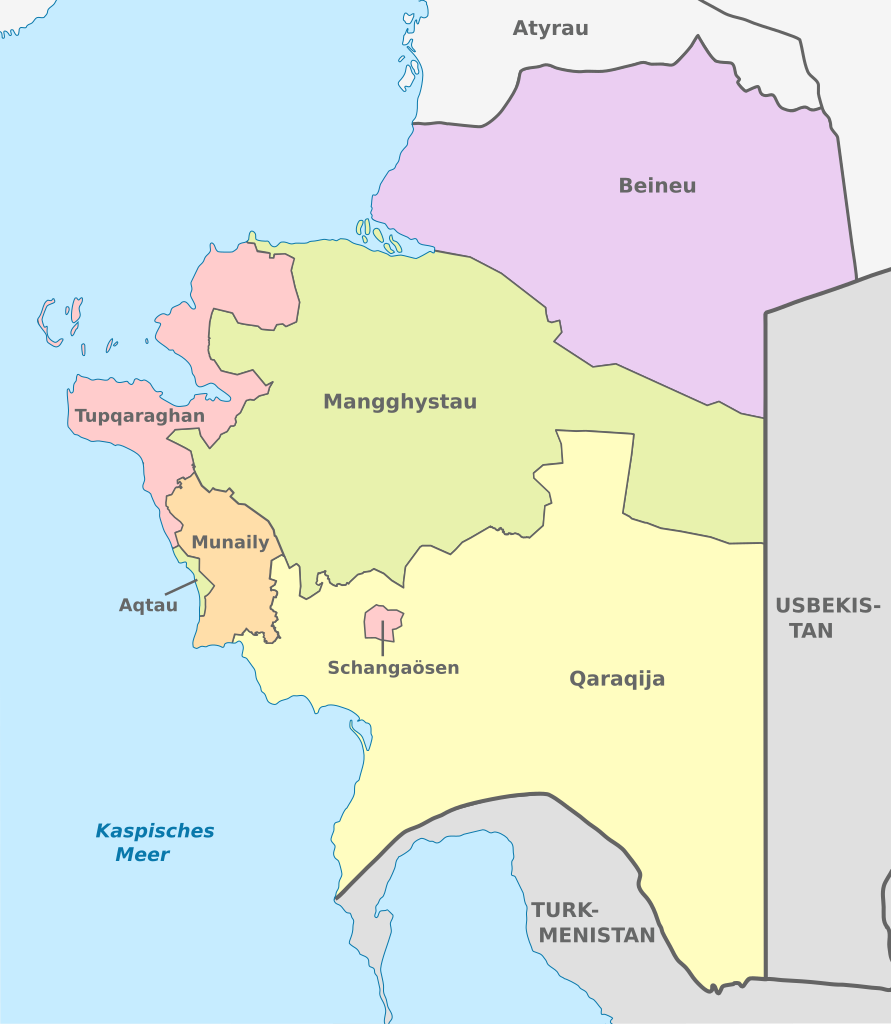
English: Map of administrative divisions of Mangystau Region, Kazakhstan
Deutsch: Karte der politischen Gliederung des Gebiets Mangghystau, Kasachstan |
||
| Date | |||
| Source |
Own work This vector image includes elements that have been taken or adapted from this file: This vector image includes elements that have been taken or adapted from this file: |
||
| Author | Zebra848 | ||
| Other versions |
|
I, the copyright holder of this work, hereby publish it under the following licenses:
This file is licensed under the Creative Commons Attribution-Share Alike 3.0 Unported license.
- You are free:
- to share – to copy, distribute and transmit the work
- to remix – to adapt the work
- Under the following conditions:
- attribution – You must give appropriate credit, provide a link to the license, and indicate if changes were made. You may do so in any reasonable manner, but not in any way that suggests the licensor endorses you or your use.
- share alike – If you remix, transform, or build upon the material, you must distribute your contributions under the same or compatible license as the original.

|
Permission is granted to copy, distribute and/or modify this document under the terms of the GNU Free Documentation License, Version 1.2 or any later version published by the Free Software Foundation; with no Invariant Sections, no Front-Cover Texts, and no Back-Cover Texts. A copy of the license is included in the section entitled GNU Free Documentation License. |
You may select the license of your choice.
File history
Click on a date/time to view the file as it appeared at that time.
| Date/Time | Thumbnail | Dimensions | User | Comment | |
|---|---|---|---|---|---|
| current | 16:57, 12 April 2020 | | 881 × 1,013 (165 KB) | Zebra848 (talk | contribs) | {{Information |description ={{en|1=Map of administrative divisions of Mangystau Region, Kazakhstan}} {{de|1=Karte der politischen Gliederung des Gebiets Mangghystau, Kasachstan}} |date =2020 |source ={{own}}{{AttribSVG|Kazakhstan adm location map.svg|NordNordWest}}{{AttribSVG|KZ Mangystau Region Outline.svg|Nzeemin}} |author =Zebra848 |other versions={{SVG labeled maps of administrative divisions (location map scheme)}} }} {{self|cc-by-sa-3.0|GFDL}}... |
You cannot overwrite this file.
File usage on Commons
There are no pages that use this file.
File usage on other wikis
The following other wikis use this file:
- Usage on de.wikipedia.org